Scan to BIM Services
Transform point cloud data into intelligent BIM models for as-built documentation, retrofit, and digital twin development.
Point Cloud to Intelligent BIM Modelling
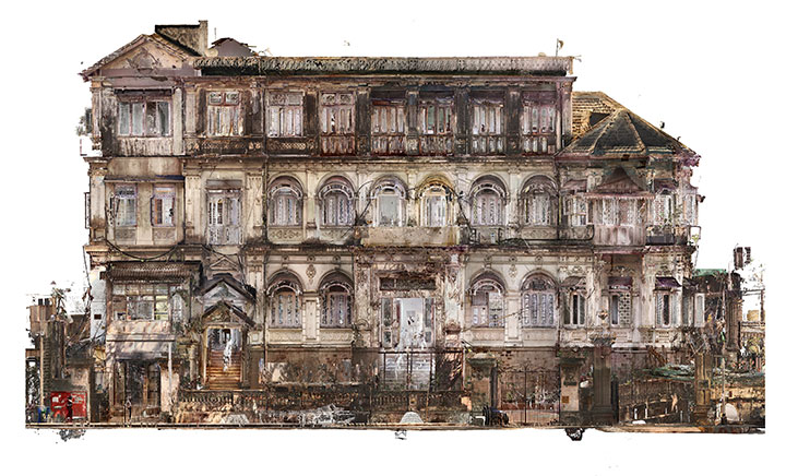
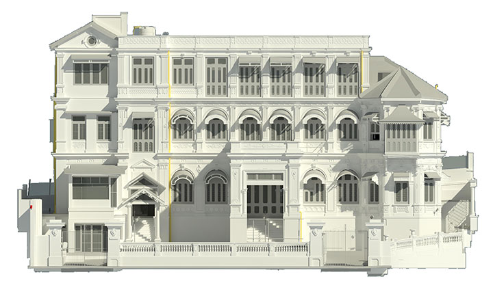
Scan to BIM is a process that converts laser-scanned point cloud data into accurate, data-rich Building Information Models. It enables precise as-built documentation, design validation, and digital twin creation for existing structures. Our Scan to BIM services transforms raw scan data into structured BIM models aligned with project requirements, BIM standards, and Level of Development (LOD) specifications.
WHAT WE DO
We convert terrestrial laser scan data and photogrammetry outputs into intelligent BIM models for architecture, engineering, and construction projects. Our models provide accurate geometry, structured data, and coordination-ready outputs for design, analysis, and facility management.
Our services support:
- As-built documentation of existing structures
- Retrofit, renovation, and refurbishment projects
- Heritage and HBIM modelling
- MEP system mapping and coordination
- Digital twin development for facility management
Scan To BIM Approach
Basic Geometry Modelling (Scan to CAD / Dump BIM)
- Geometry-focused modelling from point cloud
- Generic elements without parametric intelligence
- Fast turnaround for visualization and planning
- Suitable for concept design and spatial reference
Intelligent BIM Modelling (Data-Rich)
- Parametric Revit modelling from point cloud
- Discipline-wise modelling (Architecture, Structure, MEP)
- LOD-based modelling (LOD 200–400)
- COBie and IFC data integration
- Clash-ready coordinated BIM model
Level of Development (LOD)
We provide intelligent modelling from basic geometry to detailed parametric models with full asset data integrations.
Conceptual Mass Model
Basic building form and layout
Approximate Geometry
Generic elements with approximate dimensions
Accurate As-Built Model
Precise geometry suitable for design coordination
Coordination Model
Includes interfaces and system connections
Fabrication / FM Model
Detailed parametric model with asset data
Scan to BIM Workflow
01
Scan Data Acquisition
- Capture site using LiDAR scanners (terrestrial/mobile)
- Ensure full coverage of interiors and exteriors
- Output formats: .E57, .RCP, .LAS, .XYZ
02
Point Cloud Registration
- Register multiple scans into unified dataset
- Align scans using targets and cloud-to-cloud methods
- Generate registration report with accuracy metrics
03
Point Cloud Cleaning
- Remove noise, unwanted objects, and distortions
- Segment data by floors, zones, or disciplines
- Optimize point cloud for modelling
04
BIM Project Setup
- Import point cloud into Revit environment
- Set coordinates, levels, and grids
- Configure project template as per BEP
05
BIM Modelling
- Architectural elements (walls, floors, roofs, openings)
- Structural elements (columns, beams, slabs)
- MEP systems (ducts, pipes, cable trays, equipment)
- Parametric modelling aligned with LOD requirements
06
Coordination & Validation
- Cross-check model with point cloud data
- Perform clash detection and coordination
- Ensure dimensional accuracy and alignment
07
QC & Final Delivery
- Deviation analysis (model vs scan)
- Validate BIM standards compliance
- Deliver final BIM models and documentation
Deliverables
Benefits of Scan to BIM
- High-accuracy as-built documentation
- Reduced design errors and rework
- Improved coordination between disciplines
- Faster project turnaround and decision-making
- Enables digital twin and lifecycle management
- Supports renovation and retrofit planning
Use Cases
- Existing building documentation
- Heritage and conservation projects (HBIM)
- Industrial plant modelling
- Infrastructure and civil projects
- MEP retrofit and system upgrades
Quality Control & Standards
- ISO 19650 BIM compliance
- BEP-driven modelling workflows
- Tolerance-based accuracy verification (±5mm typical)
- Standardized naming conventions and data structure
- IFC and COBie interoperability
Frequently Asked Questions
It is the process of converting 3D laser scan data into a structured BIM model.
It improves accuracy, reduces construction errors, speeds decision-making, and provides reliable digital documentation for existing buildings and infrastructure projects.
Industries include heritage conservation, industrial plants, infrastructure, commercial buildings, retrofit projects, and MEP coordination for existing facilities.
We support common scan formats including .E57, .RCP, .LAS, and .XYZ for seamless point cloud processing and BIM model creation.
Our services provide LOD 100 to LOD 400 models based on project requirements, coordination needs, fabrication, and facility management goals.
Models are validated against point cloud data with tolerance-based verification, typically maintaining accuracy within ±5mm for reliable project coordination.
Yes, Scan to BIM helps retrofit and renovation projects by delivering precise as-built models for planning, coordination, and construction execution.
Yes, we create detailed MEP BIM models for coordination, clash detection, retrofits, and facility management integration across various project types.
Yes, clash detection and multidisciplinary coordination are performed to identify conflicts early and reduce costly on-site construction issues.
Yes, we provide IFC-compatible BIM models and COBie-integrated asset data for interoperability and facility management system integration.
Typically ±5mm depending on scan quality and project requirements.
Yes, we can process client-provided scan data in standard formats.
Yes, we deliver multi-disciplinary BIM models including architecture, structure, and MEP.
Get Started with Our Scan to BIM Services
Looking for reliable Scan to BIM services to convert your laser scan or point cloud data into accurate BIM models?
Share your scan files or project requirements, and our BIM specialists will review your data and provide a quick project evaluation and proposal.
Headquarters
Rajkot Office
Nr. Shreeji Gau Shala, B/h Tulip Party Plot
Premvati, Vavdi, Rajkot – 360004
India
Vadodara Office
Tarsali – Danteshwar Ring Road
Vadodara – 390009
General Inquiries
© 2026 Fibrox 3D. All rights reserved. | Developed by SkyWebTech