The construction industry is rapidly evolving with the adoption of advanced technologies that directly improve accuracy, efficiency, and project outcomes. One such game-changing innovation is 3D scanning in construction.
Traditional surveying methods often struggle to capture complex structures accurately and require significant time, guesswork, and manpower.
In contrast, 3D scanning provides fast, precise, and highly detailed data that helps construction project managers and professionals make radically better decisions.
From planning and initial design to final execution and facility maintenance, 3D scanning in construction is entirely transforming how projects are managed and successfully delivered.
What is 3D Scanning in Construction?
3D scanning in construction refers to the process of capturing the precise physical environment of a construction site using laser scanners or similar technologies to create highly accurate digital representations.
These devices rapidly collect millions of data points, forming what is known as a point cloud.
This point cloud data can then be used to generate actionable deliverables, including:
- 3D CAD Models
- BIM (Building Information Modeling) data
- 2D Architectural / Structural drawings
A point cloud provides a digital twin of reality, granting engineers, architects, and contractors the ability to visualize and analyze the construction site with flawless precision – all from their office.”
How 3D Scanning Works in Construction Projects
The integration of 3D scanning into a construction workflow happens through several key phases:
1. Site Assessment & Planning
Before the actual scanning begins, a proper site assessment is conducted. Professionals determine key areas to be scanned, optimal scanner positions, required accuracy levels, and intended project deliverables (like Scan-to-BIM or simple clash detection).
2. Site Setup
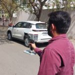
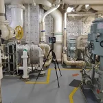
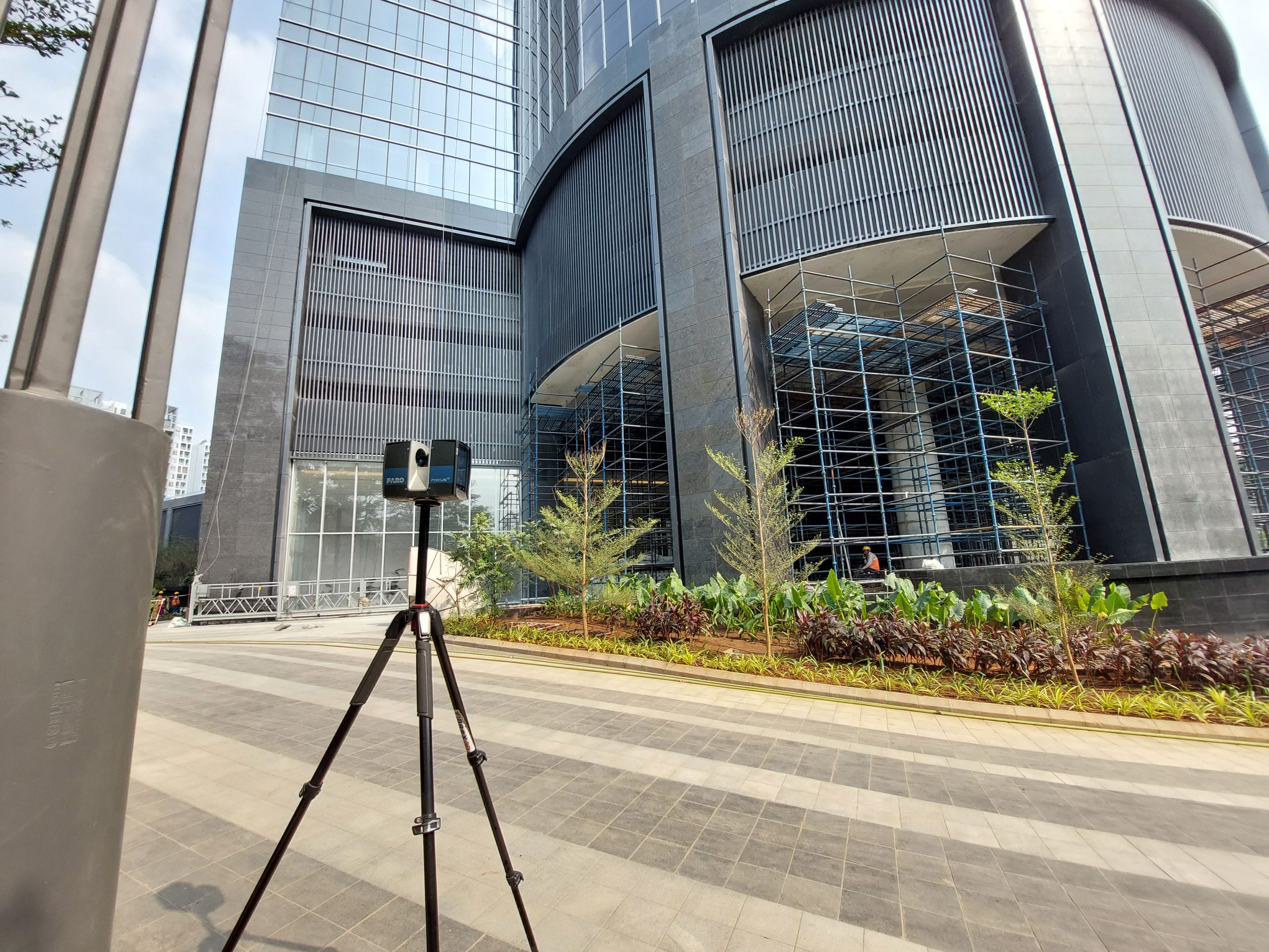
Once planning is complete, the laser scanner is set up at multiple strategic locations across the construction site. These scanners are typically mounted on tripods to maintain strict stability. Multiple scan targets are utilized to ensure that different angles are captured and blind spots are avoided.
3. Data Capture
The scanner emits pulsed laser beams that rapidly rotate 360 degrees to scan the surrounding environment. These beams hit physical surfaces and immediately return to the scanner, allowing the device to measure exact distances down to the millimeter.
4. Data Registration & Modeling
Since multiple scans are taken from different positions, they must be aligned together and merged through a digital process called Registration. Once aligned, the cleaned point cloud data is natively imported into software like Revit or AutoCAD to begin generating 3D or 2D geometry.
Watch how scanning transforms the job site:
Types of 3D Scanning Technologies Used in Construction
1. Terrestrial Laser Scanning:
Terrestrial Laser Scanning uses a stationary ground-based scanner placed at fixed points around a site. It captures extremely dense and highly accurate 3D measurements, making it ideal for detailed documentation.
This method is commonly used for buildings, factories, bridges, and complex industrial structures where millimeter-level accuracy is required
Best suited for:
- As-built documentation of buildings
- Structural inspections
- Renovation and retrofit projects
- Complex mechanical or industrial sites
2. Mobile Laser Scanning
Mobile Laser Scanning systems are mounted on moving platforms such as vehicles, backpacks, or handheld devices. Unlike stationary scanning, this method captures data while in motion, making it much faster for covering large areas.
It is especially useful for infrastructure projects like roads, highways, tunnels, and railway networks where speed and coverage are more important than ultra-fine detail.
Best suited for:
- Road and highway mapping
- Railway and tunnel surveys
- Large construction site monitoring
- Rapid topographic data collection
3. Drone (UAV) Scanning
Drone-based 3D scanning uses UAVs equipped with LiDAR sensors or high-resolution cameras for photogrammetry. It allows engineers to capture large or difficult-to-access areas from the air with minimal manual effort.
Best suited for:
- Large construction sites and land surveys
- Earthwork volume calculations
- Progress monitoring over time
- Hard-to-reach or hazardous areas
4. Photogrammetry (Camera-Based 3D Scanning)
Photogrammetry uses overlapping images taken from drones or cameras to reconstruct 3D models. Instead of lasers, it relies on visual data and software processing.
It is cost-effective and widely used, especially when ultra-high accuracy is not critical.
Best suited for:
- Site surveys and mapping
- Progress tracking
- Visual documentation
- Budget-friendly 3D modeling
Benefits of 3D Scanning in Construction
- High Accuracy & Precision: Captures highly accurate measurements for reliable project data.
- Faster Project Execution: Scans large areas quickly, reducing overall timelines.
- Cost Savings: Minimizes errors, rework, and material wastage.
- Improved Safety: Enables remote data capture, reducing on-site risks.
- Better Visualization & Planning: Provides clear 3D models for smarter decision-making.
- Comprehensive Data Capture: Records complete site details without missing information.
- Reduced Rework: Identifies issues early, preventing costly corrections later.
- Efficient Project Management: Improves coordination between teams and stakeholders.
- Clash Detection: Helps detect design conflicts before construction begins.
1. High Initial Investment
One of the primary challenges of 3D scanning in construction is the upfront cost. High-quality laser scanners, software, and skilled professionals can require a significant investment.
Although the technology saves money in the long run by reducing errors and rework, the initial cost can be a barrier for small or mid-sized projects.
2. Skilled Expertise Required
Operating laser scanning equipment and processing the data is not straightforward. It requires trained professionals with expertise in:
- Data capture techniques
- Point cloud processing
- BIM and CAD integration
A lack of skilled personnel can impact data quality and project outcomes.
3. Environmental & Site Conditions
External factors can affect scanning accuracy and efficiency:
- Rain, fog, or dust can interfere with laser signals
- Reflective or transparent surfaces (glass, water) can cause inaccuracies
- Poor lighting or extreme conditions may impact results
Proper planning is necessary to minimize these issues.
4. Data Accuracy Depends on Setup
Although 3D terrestrial laser scanning is highly accurate, errors can occur due to:
- Improper scanner positioning
- Incorrect calibration
- Poor alignment of multiple scans
Accuracy depends heavily on how well the scanning process is executed.
5. Limited Real-Time Capabilities
Unlike some modern digital tools, traditional terrestrial laser scanning does not always provide real-time results.
- Data often needs post-processing
- Immediate decision-making may be delayed
- Not ideal for highly dynamic environments
What Makes Fibrox the Right Choice for 3D Scanning in Construction?
High-Precision Data Capture
We utilize state-of-the-art laser scanning technology to capture highly accurate and detailed site data. This ensures every measurement is reliable, helping you make confident decisions during design and execution.
BIM-Ready Outputs
Our deliverables are structured for immediate use in BIM workflows. From point clouds to fully developed models, we provide data that integrates seamlessly into your design and construction processes.
Proven Industry Expertise
With hands-on experience across construction, infrastructure, and industrial projects, we understand real-world challenges and deliver solutions tailored to your specific project requirements.
End-to-End Project Support
From initial site scanning to final deliverables, Fibrox manages the complete process. Our streamlined approach ensures consistency, efficiency, and minimal disruption to your project timeline.
Reliable & Timely Delivery
We understand the importance of deadlines in construction projects. Our team is committed to delivering high-quality results on time, helping you keep your project on track.
Cost-Effective & Efficient Solutions
By reducing errors, minimizing rework, and improving workflow efficiency, our 3D scanning in construction services help optimize overall project costs.
Conclusion
3D scanning in construction is transforming how projects are planned, executed, and managed in today’s fast-evolving industry. By delivering highly accurate, fast, and detailed data, it enables construction professionals to work with greater confidence and precision.
From improving design accuracy to reducing rework and enhancing collaboration, this technology plays a critical role in achieving efficient and cost-effective project outcomes. As construction projects become more complex, adopting 3D scanning in construction is no longer an option – it’s a necessity for staying competitive and delivering high-quality results.
FAQs
1. What is 3D scanning in construction?
3D scanning in construction is the process of capturing real-world site conditions using laser scanning technology to create accurate digital 3D data, such as point clouds, models, and drawings.
2. How is 3D scanning used in construction projects?
It is used for various applications, including site surveys, as-built documentation, BIM (Scan-to-BIM) modeling, clash detection, and project planning.
3. Is 3D scanning in construction expensive?
While the initial investment may be higher than traditional methods, it significantly reduces costs in the long run by minimizing errors, rework, and project delays.
4. What are the key benefits of 3D scanning in construction?
Major benefits include high accuracy, faster data capture, improved safety, cost savings, better visualization, and enhanced project coordination.
5. Can 3D scanning be used for renovation and retrofit projects?
Yes, 3D scanning is highly effective for renovation projects as it captures precise existing conditions, making planning and modifications more accurate and efficient.