In today’s data-driven world, businesses require accurate and up-to-date information to make informed decisions. Whether it’s a construction site, industrial facility, mining operation, infrastructure project, or agricultural land, precise mapping is essential for successful planning and execution. This is where drone mapping services have emerged as a game-changing solution.
By combining advanced unmanned aerial vehicles (UAVs), high-resolution sensors, GPS technology, and sophisticated data-processing software, drone mapping delivers highly accurate geospatial data faster and more efficiently than traditional surveying methods. From creating detailed orthomosaic maps to generating 3D models and terrain analysis, drone mapping services provide valuable insights for a wide range of industries.
In this guide, we’ll explore the process, technology, and benefits of drone mapping services and understand why organizations worldwide are adopting this innovative approach to surveying and site documentation.
What is Drone Mapping Service?
Drone mapping services involve the use of drones equipped with specialized cameras, LiDAR sensors, GPS systems, and mapping software to capture aerial data and create accurate digital representations of physical environments.
Unlike standard aerial photography, drone mapping focuses on collecting geospatially accurate data that can be processed into various outputs, including:
- Orth mosaic maps
- Digital Elevation Models (DEM)
- Digital Surface Models (DSM)
- 3D terrain models
- Point cloud data
- Topographic maps
- Volume calculations
These deliverables help engineers, surveyors, architects, project managers, and asset owners gain a comprehensive understanding of project sites and existing conditions.
How Drone Mapping Works: Step-by-Step Process
Step 1: Project Planning and Site Assessment
The drone mapping process begins with understanding project objectives, site conditions, required accuracy levels, and survey scope. This planning phase ensures efficient operations, regulatory compliance, and successful data collection.
Step 2: Flight Mission Planning
Survey professionals create an automated flight plan by defining altitude, flight paths, image overlap, and coverage area. Proper mission planning helps capture complete, accurate, and consistent site data.
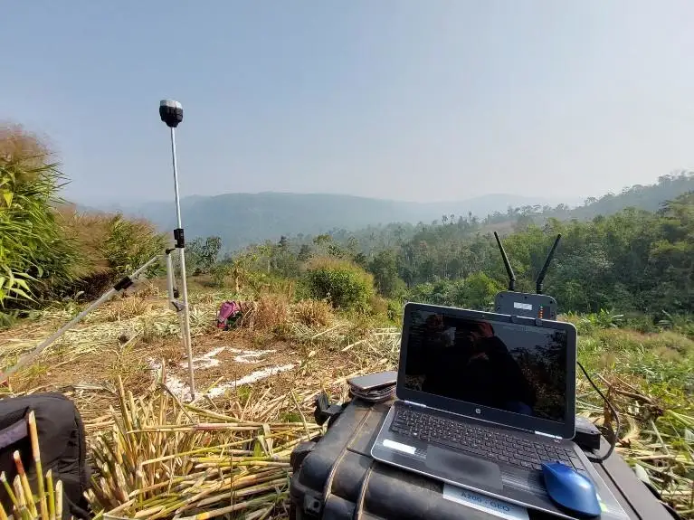
Step 3: Ground Control Point Setup
When high accuracy is required, Ground Control Points (GCPs) are strategically placed across the survey area. These reference points improve geospatial accuracy and enhance mapping precision.
Step 4: Drone Data Collection
The drone follows the predefined flight path while capturing high-resolution images or LiDAR data. Thousands of data points are collected quickly, covering large areas with exceptional detail.
Step 5: Data Processing and Alignment
Specialized software processes captured images by aligning overlapping photographs, identifying common points, and generating a georeferenced dataset. This transforms raw data into usable mapping information.
Step 6: Point Cloud and Model Generation
Processed data is converted into dense point clouds, orthomosaic maps, digital elevation models, and 3D representations. These outputs provide a detailed understanding of site conditions.
Step 7: Quality Verification
Mapping experts review the generated data for accuracy, completeness, and consistency. Any discrepancies are corrected to ensure the final deliverables meet project requirements and industry standards.
Step 8: Deliverable Creation and Reporting
Final outputs such as orthomosaic maps, contour maps, 3D models, and survey reports are prepared. These deliverables support planning, design, construction, and informed decision-making processes.
Step 9: Client Review and Project Delivery
The completed drone mapping deliverables are shared with stakeholders in compatible formats. Clients can easily integrate the data into CAD, BIM, GIS, and engineering workflows.
Technologies Used in Drone Mapping
The effectiveness of drone mapping services depends on advanced technologies working together to capture and process accurate data.
UAV Platforms
Modern drone mapping utilizes different types of UAVs depending on project requirements.
Multirotor Drones
- Ideal for detailed inspections
- Suitable for confined areas
- Excellent maneuverability
Fixed-Wing Drones
- Cover larger areas quickly
- Longer flight endurance
- Efficient for corridor mapping projects
Photogrammetry Technology
Photogrammetry is one of the most widely used methods in drone mapping.
It works by:
- Capturing overlapping images
- Identifying common points
- Reconstructing 3D geometry
- Creating accurate maps and models
Photogrammetry provides detailed visual information and high-resolution outputs.
LiDAR Mapping Technology
LiDAR (Light Detection and Ranging) uses laser pulses to measure distances and create highly accurate 3D point clouds.
Benefits include:
- Exceptional accuracy
- Ability to penetrate vegetation
- Effective terrain modeling
- Detailed infrastructure documentation
LiDAR is particularly valuable for complex industrial sites, forests, and topographic surveys.
GPS and RTK Systems
Accurate positioning is critical for drone mapping.
Modern drones often incorporate:
- GPS navigation
- RTK (Real-Time Kinematic) technology
- PPK (Post-Processed Kinematic) correction systems
These technologies improve positional accuracy and reduce survey errors.
GIS Integration
Geographic Information Systems (GIS) allow collected drone data to be analyzed and visualized effectively.
GIS integration helps users:
- Manage geospatial data
- Conduct spatial analysis
- Monitor assets
- Support planning decisions
This makes drone mapping data more valuable and actionable.
Key Benefits of Drone Mapping Services
1. Faster Data Collection
Traditional surveying can take days or even weeks to complete. Drone mapping significantly reduces fieldwork time by capturing large amounts of data in a single flight.
This leads to:
- Faster project completion
- Improved productivity
- Reduced operational delays
2. High Accuracy and Precision
With advanced sensors and positioning systems, drone mapping delivers highly accurate data suitable for engineering, construction, and infrastructure applications.
Organizations can make decisions based on reliable information while minimizing costly errors.
3. Cost-Effective Surveying
Drone mapping reduces the need for extensive manpower, heavy equipment, and repeated site visits.
Benefits include:
- Lower labor costs
- Reduced equipment expenses
- Improved project efficiency
4. Improved Site Safety
Surveying hazardous environments often exposes workers to risks.
Drone mapping enables remote data collection in:
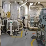
- Industrial plants
- Mining operations
- High-elevation structures
- Busy construction sites
This significantly improves worker safety.
5. Access to Hard-to-Reach Areas
Drones can safely access locations that are difficult or dangerous for traditional survey teams.
Examples include:
- Dense vegetation
- Steep slopes
- Remote infrastructure
- Restricted industrial zones
6. Real-Time Project Monitoring
Regular drone surveys allow stakeholders to monitor progress and identify issues early.
Benefits include:
- Better project control
- Enhanced communication
- Faster issue resolution
- Improved reporting
Industries Benefiting from Drone Mapping
| Industry | Key Applications |
|---|---|
| Construction and Infrastructure | Site planning, progress monitoring, earthwork analysis, as-built documentation |
| Mining and Quarrying | Volume calculations, resource management, safety inspections |
| Oil and Gas | Pipeline monitoring, facility documentation, asset management |
| Manufacturing and Industrial Plants | Existing condition surveys, expansion planning, digital twin creation |
| Agriculture | Crop health monitoring, irrigation planning, field mapping |
| Utilities and Power Transmission | Transmission line inspections, asset inventory management, maintenance planning |
| Urban Planning | Land-use analysis, infrastructure development, smart city initiatives |
Conclusion
Drone mapping services are revolutionizing how organizations collect, analyze, and utilize geospatial data. By combining advanced UAV technology, photogrammetry, LiDAR, GPS systems, and GIS integration, businesses can achieve faster, safer, and more accurate surveying results than ever before.
From construction and infrastructure projects to industrial facilities, mining operations, and agriculture, drone mapping provides valuable insights that support better planning, improved efficiency, and informed decision-making.
FAQs
1. What are drone mapping services?
Drone mapping services use drones equipped with cameras and sensors to capture aerial data and create accurate maps, 3D models, point clouds, and terrain representations.
2. How accurate is drone mapping?
With RTK, PPK, and advanced processing technologies, drone mapping can achieve survey-grade accuracy suitable for engineering and infrastructure projects.
3. What industries use drone mapping services?
Construction, mining, oil and gas, manufacturing, utilities, agriculture, and urban planning industries commonly use drone mapping services.
4. What deliverables can be generated from drone mapping?
Typical outputs include orthomosaic maps, DEMs, DSMs, contour maps, point clouds, volume calculations, and 3D models.
5. Is drone mapping better than traditional surveying?
Drone mapping often provides faster data collection, broader coverage, enhanced safety, and rich visual data, making it an excellent complement or alternative to traditional surveying methods.