In today’s fast-paced construction and engineering landscape, accuracy and efficiency are more important than ever.
Traditional measurement methods often fall short when it comes to capturing complex structures. This is where 3D terrestrial laser scanning comes in as a powerful and reliable solution.
From infrastructure development to heritage preservation, this advanced technology is transforming how professionals collect, analyze, and use spatial data. In this comprehensive guide, we will explore what 3D terrestrial laser scanning is, its core benefits, and its wide range of applications across global industries.
What is 3D Terrestrial Laser Scanning?
3D terrestrial laser scanning is an advanced surveying technology that uses laser beams to capture highly accurate 3D measurements of physical environments.
It creates detailed point cloud data, which can then be converted into 3D models, CAD drawings, and BIM models for high-level analysis and planning.
This technology is widely used in construction, infrastructure, industrial projects, and heritage preservation due to its speed, precision, and efficiency.
“Terrestrial laser scanning isn’t just about taking faster measurements; it’s about eliminating the costly unknowns in complex industrial environments.”
Watch: 3D Terrestrial Laser Scanning Explained in under 2 minutes:
How 3D Terrestrial Laser Scanning Works
The process of terrestrial laser scanning involves capturing millions of data points in a remarkably short time. Here’s a step-by-step breakdown of how it works:
- Scanner Setup: A laser scanner is carefully placed on a tripod at a fixed position on-site.
- Laser Emission: The scanner emits thousands to millions of laser points per second in a 360-degree sweep.
- Data Capture: Each laser beam reflects back after hitting a surface, recording the precise distance and angle.
- Point Cloud Generation: All collected points form a dense, digital 3D dataset called a point cloud.
- Processing & Modeling: The field data is processed in the office and converted into highly accurate 3D Models, 2D CAD Drawings, and intelligent BIM Models.
Types of 3D Terrestrial Laser Scanners
Not all laser scanners are built the same. The right scanner depends largely on the project’s requirements, specifically regarding range and precision.
1. Time-of-Flight (ToF) Scanners
Time-of-flight scanners measure the actual time taken by a laser pulse to travel to the surface and return.
- Ideal for long-range scanning
- Works best for infrastructure and large-scale architectural projects
- Slightly slower data capture compared to phase-shift, but with much greater distance capabilities.
2. Phase-Shift Scanners
These scanners emit a continuous laser beam and calculate distance using phase differences between the emitted and returned waves.
- Noticeably faster data capture
- Best suited for short-range, high-precision environments like MEP rooms or heritage sites
- High detail, but limited to closer distances (usually under 100 meters).
Benefits of 3D Terrestrial Laser Scanning
1. High Accuracy & Precision
One of the most significant advantages of 3D terrestrial laser scanning is its exceptional level of accuracy. The technology captures millions of data points with millimeter-level precision, ensuring that every detail of the physical environment is recorded accurately.
This high level of precision is crucial for projects where even minor errors can lead to costly rework or design issues. Whether it’s complex industrial facilities or detailed architectural structures, laser scanning provides reliable data that engineers, architects, and designers can confidently use for planning and execution.
2. Faster Data Collection
Traditional surveying methods can be time-consuming and often require multiple site visits. In contrast, terrestrial laser scanning dramatically speeds up the data collection process.
Modern scanners can capture millions of points per second, allowing large areas or complex structures to be documented in a matter of hours. This efficiency not only reduces project timelines but also minimizes disruptions on-site, making it ideal for active construction sites or operational facilities.
Faster data collection also enables quicker decision-making, helping projects move forward without unnecessary delays.
3. Cost Efficiency
Although the initial investment in 3D terrestrial laser scanning may seem higher than conventional methods, it proves to be highly cost-effective in the long run.
Accurate data capture reduces the likelihood of errors, rework, and design conflicts, which are often the most expensive parts of any project. By identifying potential issues early, stakeholders can avoid costly corrections during later stages of construction or implementation.
Additionally, fewer site visits and reduced labor requirements contribute to overall cost savings, making laser scanning a smart financial choice for modern projects.
4. Enhanced Safety
Safety is a critical concern in industries such as construction, mining, and industrial operations. Terrestrial laser scanning significantly improves safety by allowing data to be captured remotely.
Surveyors and engineers can collect accurate measurements without physically accessing dangerous or hard-to-reach areas, such as high elevations, confined spaces, or hazardous environments. This reduces the risk of accidents and ensures compliance with safety regulations.
By minimizing human exposure to risky conditions, laser scanning creates a safer working environment for all project stakeholders.
5. Comprehensive Data Capture
Another major benefit of terrestrial laser scanning is its ability to capture complete and detailed datasets. Unlike traditional methods that record only selected points, laser scanners collect dense point clouds that represent the entire environment.
This comprehensive data capture ensures that no detail is overlooked, which is especially important for complex projects like industrial plants, heritage structures, or infrastructure developments. The collected data can be revisited at any time, eliminating the need for repeated site visits.
Furthermore, this rich dataset supports multiple applications, including 3D modeling, BIM integration, clash detection, and digital twin creation.
6. Improved Project Planning & Visualization
With detailed 3D data, teams can visualize projects more effectively before execution. 3D terrestrial laser scanning enables the creation of accurate digital models that help stakeholders understand the project scope, identify potential challenges, and plan accordingly.
This improved visualization leads to better communication among teams, reduces misunderstandings, and ensures smoother project execution.
7. Better Decision-Making
Having access to accurate and comprehensive data allows project managers and engineers to make informed decisions. Terrestrial laser scanning provides real-world insights that improve design accuracy, reduce uncertainties, and enhance overall project outcomes.
8. Versatility Across Applications
The flexibility of 3D terrestrial laser scanning makes it suitable for a wide range of applications, from construction and infrastructure to heritage preservation and industrial maintenance. This adaptability makes it a valuable tool for businesses looking to improve efficiency and accuracy across multiple projects.
Applications of 3D Terrestrial Laser Scanning
The versatility of 3D terrestrial laser scanning makes it valuable across multiple industries:
1. Architecture, Engineering & Construction (AEC)
- As-built documentation
- BIM modeling
- Clash detection
- Renovation and retrofitting
2. Infrastructure & Civil Projects
- Roads, bridges, and railways
- Urban planning
- Utility mapping
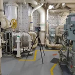
3. Industrial Plants & Facilities
- Plant design and upgrades
- Equipment layout planning
- Maintenance and inspection
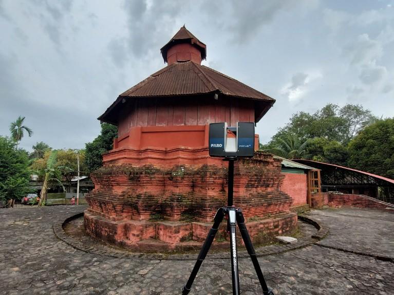
4. Heritage & Cultural Preservation
- Digital documentation of monuments
- Restoration and conservation planning
- Historical site preservation
5. Mining & Topographic Surveys
- Terrain mapping
- Volume calculations
- Site monitoring
Industries Using 3D Terrestrial Laser Scanning
Many industries rely on terrestrial laser scanning for precision and efficiency, including:
- Construction & Real Estate
- Oil & Gas
- Manufacturing
- Transportation
- Surveying & Geospatial Services
Why Choose Fibrox for 3D Terrestrial Laser Scanning?
At Fibrox, we combine cutting-edge technology with practical industry experience to deliver high-quality 3D scanning solutions tailored to your project needs.
1. High-Quality Data Capture
We use advanced laser scanning equipment to capture highly accurate and detailed point cloud data, ensuring reliable results for design, analysis, and planning.
2. Advanced Processing & Modeling
We convert raw data into:
- 3D models
- CAD drawings
- BIM models
- Digital twins
3. Industry-Specific Expertise
Fibrox delivers customized solutions across multiple sectors, including construction, infrastructure, industrial facilities, and heritage projects, ensuring your specific requirements are met.
4. End-to-End Solutions
From on-site data capture to final deliverables, we provide complete support throughout the project lifecycle, making the entire process seamless and efficient.
5. Reliable & Timely Project Delivery
We understand the importance of deadlines. Our streamlined workflows and experienced team ensure projects are completed on time without compromising quality.
6. Cost-Effective Approach
By minimizing errors, reducing rework, and improving efficiency, our services help you save both time and overall project costs.
Conclusion
3D terrestrial laser scanning is transforming how industries capture and utilize spatial data. With its unmatched accuracy, speed, and versatility, it has become an essential tool for modern projects.
From construction and infrastructure to heritage preservation, the benefits of terrestrial laser scanning are undeniable. By adopting this technology, businesses can improve efficiency, reduce costs, and achieve better project outcomes.
FAQs
1. What is 3D terrestrial laser scanning used for?
3D terrestrial laser scanning is used to capture highly accurate 3D data of physical environments. It is widely applied in construction, BIM modeling, surveying, infrastructure projects, and heritage preservation.
2. How accurate is terrestrial laser scanning?
Terrestrial laser scanning provides millimeter-level accuracy, making it highly reliable for precise measurements, detailed modeling, and engineering applications.
3. Is 3D terrestrial laser scanning expensive?
While the initial cost may be higher than traditional methods, it is cost-effective in the long term by reducing errors, minimizing rework, and improving overall project efficiency.
4. What industries benefit from terrestrial laser scanning?
Industries such as construction, infrastructure, oil & gas, manufacturing, and heritage conservation benefit significantly from terrestrial laser scanning technology.
5. How long does a terrestrial laser scanning project take?
The duration depends on the project size and complexity, but data capture is typically fast and can often be completed within a few hours, with additional time required for processing and modeling.