Introduction:
Before planning a renovation, modifying an industrial facility, or upgrading existing building systems, project teams need to understand the site’s actual condition. However, existing drawings do not always reflect what has been constructed. Changes made during construction, undocumented installations, and differences between design and execution can create gaps between drawings and reality.
At Fibrox 3D, we recognise that reliable as-built documentation starts with accurate site data. Traditional surveying and manual measurements remain useful for many applications, but complex structures and facilities often require more comprehensive data collection.
In this guide, we explain how 3D scanning supports as-built documentation, where it is most useful, and what to consider when choosing a scanning approach for your project.
What Is 3D Scanning for As-Built Documentation?
As-built documentation records the actual dimensions, layout, and configuration of a building, structure, or facility as it exists in the real world.
Unlike design drawings, which represent the intended construction, as-built records document the conditions found on-site. These records can include building dimensions, structural elements, equipment locations, piping arrangements, and other installed components.
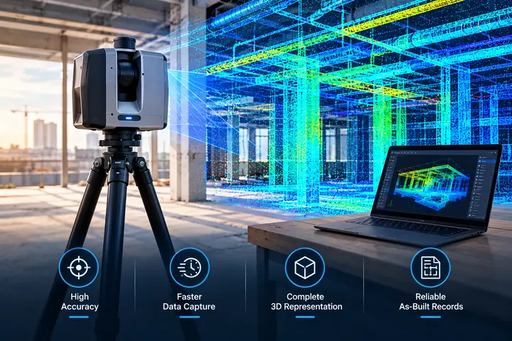
3D laser scanning services use laser-based measurement technology to capture spatial information from physical environments. The collected measurements are processed into a point cloud, which represents the scanned surfaces as millions of individual data points.
Depending on project requirements, this data can be used to produce:
- Accurate point cloud datasets for design and engineering reference.
- 2D as-built drawings, including plans, sections, and elevations.
- Existing-condition 3D models for design and coordination.
- Scan-to-BIM models for renovation and facility planning.
- Digital records for future maintenance, upgrades, and modifications.
The final deliverables depend on the scanning scope, required level of detail, and intended use of the data.
Top Benefits of Using 3D Scanning for As-Built Documentation
1. Unmatched Accuracy and Precision
With millimeter precision, 3D scanners gather data to make sure that as-built documentation is, with the least possible number of errors, closer to reality. Precision has special significance in industries such as construction and manufacturing, where minor deviations can result in expensive mistakes or even structural problems.
2. Efficiency and Speed
The 3D scanning service provider is used for documenting as-built conditions because of the speed with which this documentation can be done compared to traditional methods that may take days or weeks. Today, scanners can record millions of points in an instant, allowing us to survey large areas or complex structures in a very short amount of time.
3. Comprehensive Data Collection
Structure or environment details are preserved in 3D Scanning, producing complete digital duplicates. No more multiple site visits or missed measurements; all data is captured in a single scan.
4. Versatility across Applications
3D scans can be used for projects involving buildings and industrial plants, historical monuments, or mechanical systems. That versatility makes it a boon for architects, engineers, contractors, and preservationists alike.
5. Enhanced Collaboration
3D Scanning produces digital models that can be easily distributed and integrated with BIM or another collaboration platform. This enhances communication between stakeholders, allowing for informed decisions and a smoother project workflow.
6. Cost Savings
Though 3D scanning hardware comes with upfront costs, it saves money simply by needing less labor, remaining highly accurate, and producing faster timelines. Moreover, by capturing relevant data here, there is less likelihood of any expensive rework or design modifications during the lifetime of a project.
Where Is 3D Scanning Used for As-Built Documentation?
Construction and Building Renovation
Scanning existing buildings helps architects, contractors, and engineers document actual dimensions before renovation, refurbishment, or extensions. It is particularly useful when existing drawings are outdated or when the building contains irregular architectural features.
Industrial Plants and Manufacturing Facilities
Industrial environments often include complex piping, machinery, steel structures, and equipment installations. 3D scanning captures the accessible geometry of these components, supporting plant modifications, equipment replacement, and layout planning.
MEP Systems and Building Services
Accurate spatial information is important when coordinating HVAC ducts, electrical services, pipework, and other building systems. Point cloud data and derived as-built models can help teams review clearances and identify potential coordination issues.
Heritage Buildings and Historical Structures
For heritage projects, scanning provides a detailed digital record of accessible architectural surfaces and structural features. This information can support conservation planning, restoration documentation, and future comparisons without relying entirely on manual measurements.
Infrastructure and Marine Facilities
Bridges, transport infrastructure, ships, and offshore facilities can contain complex geometry and difficult-to-access areas. When access and scanning conditions permit, 3D scanning can support dimensional documentation, retrofit planning, and maintenance-related assessments.
3D Scanning vs Traditional As-Built Surveying
Traditional surveying and 3D laser scanning serve related but different purposes. The right approach depends on the size of the site, required accuracy, complexity, and final deliverables.
| Factor | Traditional surveying | 3D laser scanning |
|---|---|---|
| Data collection | Selected measurements and survey points | Dense spatial measurements across visible surfaces |
| Complex geometry | May require additional individual measurements | Captures detailed geometry across multiple scan positions |
| Site coverage | Depends on survey scope and method | Can document extensive areas with suitable scan coverage |
| Digital outputs | Survey drawings and measured points | Point clouds, with drawings and models developed as required |
| Best suited for | Control points, boundaries, and targeted measurements | Detailed existing-condition documentation and complex environments |
These methods can complement each other. Survey control and additional measurements may be needed to establish coordinates, verify critical dimensions, or document areas that scanning cannot capture adequately.
Challenges of Traditional As-Built Documentation
Conventional as-built documentation methods, such as hand surveying or 2D blueprints, usually prove inadequate for the needs of the modern project:
- Administrative mistakes: Manual measures have errors; this can cause a difference between the registered situation and the real situation.
- Incompleteness: Too limited tools and methods often lead to missing data or incomplete information.
- Labor-Intensive: Using traditional methods to document large or complex structures tends to be labor-intensive and time-consuming.
- Time-Consuming: It can never easily be revisited or adapted in other digital workflows, so it becomes mainly good for dynamic projects.
- Inflexibility: The solution has many limitations, and 3D Scanning overcomes them with faster and quicker methods while offering maximum flexibility, too.
Conclusion
Accurate as-built documentation is essential when decisions depend on the actual condition of a building, industrial plant, or infrastructure asset. When existing drawings are incomplete or site geometry is complex, 3D laser scanning provides a practical way to capture detailed spatial information for further analysis and documentation.
From point cloud data and as-built drawings to Scan-to-BIM models, the technology supports better design coordination, more informed planning, and reliable digital records for future modifications.
At Fibrox 3D, we focus on capturing existing conditions and developing usable digital deliverables according to project requirements. The right scanning approach depends on the site, the required accuracy, and how the resulting data will be used.
If your project requires detailed existing-condition documentation, connect with Fibrox 3D to discuss the scanning scope and suitable deliverables.
FAQs
1. How does 3D scanning improve as-built documentation?
It captures precise site conditions quickly, creating detailed digital records that reduce measurement errors and missing information.
2. Can 3D scanning reduce as-built documentation costs?
Yes, faster data collection, reduced labor, and fewer errors can help lower surveying and rework costs.
3. What industries use 3D scanning for as-built documentation?
Construction, manufacturing, facility management, MEP, heritage preservation, offshore, and industrial sectors commonly use 3D scanning.
4. Can 3D scanning data integrate with BIM models?
Yes, point cloud data can be processed and integrated into BIM workflows for accurate design, coordination, and project management.
5. How often should as-built conditions be documented?
Scanning should be performed at key project stages, especially after construction, renovation, modifications, or major installations.