The construction and infrastructure industries are increasingly adopting digital technologies to improve measurement accuracy, project planning, and coordination. From documenting existing buildings to capturing complex industrial structures, reliable site data plays an important role in making informed engineering decisions.
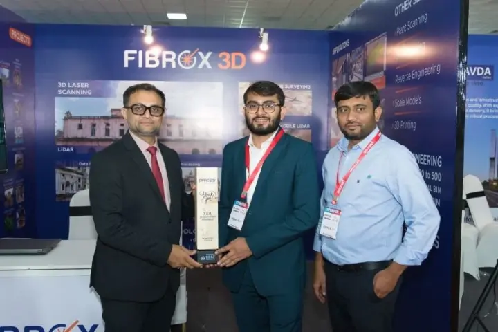
FIBROX 3D Technologies P. Ltd. participated in the PMCEA Summit 2026, held on 7 and 8 October 2026 at Vigyan Bhavan Hall, Science City, Ahmedabad, Gujarat. The event provided an opportunity to connect with professionals working across construction, infrastructure, architecture, and engineering.
With expertise in 3D laser scanning, LiDAR, drone surveying, and digital modeling, Fibrox 3D supports projects that require accurate reality capture and dependable digital information.
Fibrox 3D at PMCEA Summit 2026
The PMCEA Summit 2026 brought together professionals from the project management, construction, engineering, and related industries. Events of this nature create opportunities for businesses and technical teams to exchange ideas, explore industry developments, and understand evolving project requirements.
Fibrox 3D’s participation highlighted the importance of modern surveying and digital engineering technologies in capturing real-world conditions and translating them into usable project data.
For construction and infrastructure projects, accurate information about existing site conditions is essential. Traditional measurement methods can become challenging when working with large structures, complex geometries, restricted spaces, or buildings with limited documentation.
Advanced 3D scanning and surveying technologies help address these challenges by capturing detailed spatial information that can support design development, renovation, verification, and project coordination.
Fibrox 3D’s Scanning and Digital Engineering Capabilities
Fibrox 3D provides reality capture and digital modeling solutions that help clients document existing physical environments and develop useful digital deliverables for engineering and construction projects.
1. 3D Laser Scanning
3D laser scanning captures the geometry of buildings, industrial facilities, equipment, and other physical structures as detailed point cloud data. This information provides a digital representation of existing conditions that can be used for measurement, documentation, and engineering workflows.
For renovation, retrofitting, and infrastructure projects, 3D laser scanning helps teams understand actual site conditions before making design or installation decisions.
Fibrox 3D delivers scanning-based data capture and modeling solutions according to project requirements, helping engineering teams work with accurate representations of existing structures.
2. LiDAR and Mobile Mapping
LiDAR technology uses laser-based measurements to capture spatial information from surrounding environments. Depending on the equipment and survey setup, LiDAR can support the documentation of buildings, infrastructure corridors, industrial facilities, and large sites.
Mobile LiDAR solutions are particularly useful when spatial data needs to be captured across extensive areas or along routes. The resulting datasets can support mapping, asset documentation, and engineering analysis.
These technologies help project teams understand the relationship between existing structures, surrounding features, and available space.
3. Drone Surveying
Drone surveying provides an efficient approach to collecting aerial information across large or difficult-to-access sites. Depending on the sensors, flight plan, and processing workflow, drone surveys can generate orthomosaic maps, digital surface models, terrain information, and 3D representations.
These outputs can support site planning, topographic assessment, infrastructure documentation, and construction progress monitoring.
For projects involving extensive land areas, elevated structures, or challenging terrain, drone surveying can complement ground-based measurement and scanning methods.
4. 3D Modeling and Scan-to-BIM
Captured spatial data becomes more valuable when it is converted into information that design and construction teams can use.
3D modeling transforms point clouds and other survey data into digital representations of physical structures. Scan-to-BIM workflows use captured site information to develop Building Information Models of existing conditions.
These models can support architectural planning, structural coordination, MEP documentation, renovation, and facility management, depending on the project scope and required level of detail.
By connecting reality capture with digital modeling, project teams can better understand existing conditions and coordinate their work around reliable site information.
Applications Across Construction and Infrastructure
Fibrox 3D’s scanning and mapping solutions support a range of applications across construction, infrastructure, and the built environment.
Construction Quality Monitoring
Captured site data can help compare documented site conditions with design information at appropriate project stages. This supports progress reviews and dimensional verification, depending on the survey scope and comparison method.
Design-to-Site Verification
Reliable site measurements help teams review whether existing conditions align with design requirements. This is particularly useful when working with complex structures or planning installations within limited spaces.
Renovation and Redevelopment Planning
Existing buildings may have undergone modifications that are not fully reflected in available drawings. Scanning and as-built documentation help establish a clearer understanding of the current structure before renovation or redevelopment work begins.
Existing MEP Coordination and Planning
Mechanical, electrical, and plumbing systems often occupy restricted spaces and intersect with architectural and structural elements. Accurate existing-condition information can support coordination and help identify potential spatial conflicts during planning.
Heritage Documentation and Conservation
Historic buildings and heritage structures often contain intricate architectural details that require careful documentation. 3D scanning can capture their geometry to support conservation records, restoration planning, and digital preservation workflows.
Interior Fit-Out and Space Planning
Accurate measurements of existing interiors help designers and project teams plan layouts, review available space, and coordinate proposed installations with existing building elements.
The Importance of Accurate Digital Site Data
Construction and engineering projects often involve multiple stakeholders, tight schedules, and complex site conditions. Inaccurate measurements or incomplete documentation can create coordination difficulties and lead to additional site visits or design revisions.
Reality capture technologies provide a practical way to document physical environments and establish a reliable foundation for subsequent project work.
However, the quality of the final deliverable depends on more than the scanning equipment alone. Survey planning, data registration, processing, verification, and modeling requirements all influence the usefulness of the output.
At Fibrox 3D, the focus is on capturing site information and developing project-specific digital deliverables that align with client requirements. Selecting the appropriate workflow helps ensure that the collected data is suitable for its intended engineering or construction application.
Connecting with the Industry at PMCEA Summit 2026
Participating in PMCEA Summit 2026 provided Fibrox 3D with an opportunity to engage with the wider construction and infrastructure community.
Industry events encourage professional interaction, knowledge exchange, and discussions about evolving project requirements. They also create opportunities to explore how surveying, scanning, and digital modeling can support the changing needs of the built environment.
As construction and infrastructure projects become more complex, accurate site data and coordinated digital documentation continue to play an important role in project planning and execution.
Fibrox 3D looks forward to continuing its work in reality capture and digital engineering, supporting clients with technology-driven solutions for complex built environments.
Conclusion
Fibrox 3D’s participation in PMCEA Summit 2026 reflects its engagement with the construction, infrastructure, and engineering community.
Through 3D laser scanning, LiDAR, drone surveying, BIM modeling, and as-built documentation, Fibrox 3D supports projects that require reliable information about existing physical conditions.
Combining accurate data capture with suitable processing and modeling workflows helps project teams understand site conditions, coordinate designs, and make informed engineering decisions.
Looking for reliable 3D scanning and digital engineering solutions for your next project?
Visit Fibrox 3D to explore its services and discuss your project requirements with the team.