Photographs can capture much more than what we see in a picture. When multiple images of the same object, building, or area are captured from different positions, they can be processed to extract measurements and create useful 3D information. This technology is known as photogrammetry.
Today, photogrammetry is used across surveying, construction, architecture, engineering, mining, heritage documentation, mapping, and 3D modeling. With modern cameras, drones, and specialized software, photographs can be transformed into point clouds, 3D models, orthomosaics, and other digital outputs.
But what is photogrammetry, how does it work, and what are the different types used for different projects?
This guide explains the main types of photogrammetry, their applications, benefits, and how Fibrox 3D uses photogrammetry as part of professional 3D data capture and modeling workflows.
What Is Photogrammetry?
Photogrammetry is a technique used to obtain measurements and three-dimensional information from photographs.
The basic principle is straightforward. Multiple photographs of the same subject are captured from different viewpoints with sufficient overlap. Photogrammetry software then identifies common points and features across the images and uses this information to reconstruct the object’s shape and position in three-dimensional space.
The resulting data can be used to create:
- 3D mesh models
- 3D point clouds
- Orthomosaic images
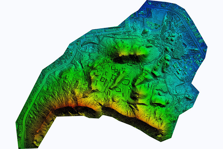
- Digital surface models
- Digital terrain models
- Topographic information
- Contours
- Digital documentation
For example, a building can be photographed from different angles. The overlapping images can then be processed to create a digital representation of the building that can be measured, inspected, documented, or used for further modeling.
At Fibrox 3D, we use photogrammetry to turn photographs into 3D models and measurement data for surveying, site documentation, 3D reconstruction, and engineering applications.
How Does Photogrammetry Work?
Understanding how photogrammetry work starts with the way photographs are captured.
A successful photogrammetry project requires more than simply taking a large number of pictures. Images need to provide enough overlap and visual information for software to identify common features and reconstruct the subject accurately.
The typical process includes the following steps.
1. Image Capture
The first step is collecting photographs of the object, structure, or site.
Images may be captured using handheld cameras, cameras mounted on tripods, drones, or other platforms depending on the project requirements.
The camera is moved around the subject or across the survey area so that important features appear in multiple photographs.
For larger sites, drone-based image capture can provide an efficient way to collect aerial data. For buildings, industrial components, heritage structures, and smaller objects, close-range photography may be more appropriate.
2. Image Overlap
Image overlap is an important part of understanding how photogrammetry works.
The same features need to appear in multiple photographs. This gives the software enough information to compare their positions from different viewpoints.
Good image overlap can help improve the reconstruction process, while poor coverage, blurred photographs, or insufficient visual features can make processing more difficult.
3. Image Alignment
Once the photographs are collected, they are imported into photogrammetry software.
The software identifies common points and features between images and determines the relative position of the cameras.
This creates an aligned image set that forms the foundation for the next stages of 3D reconstruction.
4. 3D Reconstruction
After image alignment, the software calculates the three-dimensional position of points based on their appearance in multiple photographs.
Thousands or even millions of points can be generated depending on the project, image quality, and processing settings.
These points can then form a dense point cloud representing the surfaces captured in the photographs.
5. Creating 3D Models and Other Outputs
The processed point cloud can be used to generate different digital deliverables.
Depending on the project, these may include:
- 3D mesh models
- Point clouds
- Orthomosaics
- Digital terrain models
- Digital surface models
- Contours
- Site documentation
At Fibrox 3D, the final output can be selected according to the project’s purpose, whether the requirement is visual documentation, 3D reconstruction, measurement, modeling, or further design work.
Watch Our Youtube Video:
What Are the Types of Photogrammetry?
When discussing the types of photogrammetry, classification can depend on the camera position, project scale, and intended application.
The two broad categories are generally aerial photogrammetry and terrestrial or close-range photogrammetry.
Drone or UAV photogrammetry is widely used today and is generally considered a form of aerial photogrammetry.
Let’s look at the major photogrammetry types in more detail.
1. Aerial Photogrammetry
Aerial photogrammetry involves capturing photographs from above the ground using an airborne platform.
Traditional aerial photogrammetry uses cameras mounted on aircraft, while modern projects may use drones or UAVs to capture high-resolution images over smaller areas.
Aerial photogrammetry can be useful for:
- Land surveying
- Topographic mapping
- Construction sites
- Mining areas
- Agriculture
- Roads and infrastructure
- Large properties
- Terrain mapping
- Stockpile measurements
One of its major advantages is the ability to collect information across large areas without requiring extensive ground-based photography.
Drone Photogrammetry
Drone photogrammetry has become increasingly popular because drones can capture high-resolution aerial images while covering sites efficiently.
A drone follows a planned flight path and captures overlapping images. These photographs are then processed to create outputs such as orthomosaics, point clouds, 3D models, and terrain data.
At Fibrox 3D, drone-based photogrammetry can complement other 3D data capture methods when aerial information is required for a project.
2. Terrestrial or Close-Range Photogrammetry
Terrestrial photogrammetry captures photographs from the ground.
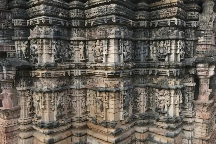
A camera can be handheld, mounted on a tripod, or positioned around the subject. The method is particularly useful for buildings, structures, industrial components, heritage sites, and objects where detailed close-range information is required.
Common applications include:
- Architectural documentation
- Heritage preservation
- Industrial equipment
- Building surveys
- Archaeology
- Product documentation
- Reverse engineering
- Construction documentation
- Engineering projects
Close-range photogrammetry can capture detailed visual information while creating a measurable digital representation of the subject.
Fibrox 3D can integrate photogrammetry with broader 3D data capture and modeling workflows depending on the requirements of the project.
3. Close-Range Photogrammetry for Objects and Structures
Close-range photogrammetry is particularly useful when the subject is relatively close to the camera and detailed information is required.
For example, photographs can be captured around an industrial component, architectural feature, heritage object, or mechanical part. The images can then be processed into a 3D representation.
This approach can be useful when visual texture and surface information are important alongside geometric information.
Is Drone Photogrammetry a Separate Type?
Drone photogrammetry is often listed separately because it is now widely used in surveying and mapping. However, technically, it is generally considered a form of aerial photogrammetry.
The main difference is the platform used to capture the images.
A drone carries the camera above the ground and captures overlapping photographs from a planned flight path. The images are then processed using photogrammetry software to generate digital outputs.
For construction, mining, surveying, agriculture, and large-site documentation, drone photogrammetry can provide an efficient way to collect aerial information.
Different Types of Photogrammetry Based on Application
The different types of photogrammetry can also be discussed according to the purpose of the project rather than only the position of the camera.
Photogrammetry for Surveying and Mapping
Photogrammetry can be used to collect spatial information for land surveys, topographic mapping, terrain analysis, and site documentation.
Aerial images can cover large areas, while close-range techniques can provide detailed information about specific structures or features.
Photogrammetry for Construction
Construction teams can use photogrammetry to document existing conditions, monitor site progress, create 3D representations, and support measurements.
Photogrammetry can provide visual documentation that can be compared over different stages of a project.
Photogrammetry for Architecture
Architectural photogrammetry can help capture buildings, façades, interiors, and existing structures.
The resulting data can support documentation, renovation, restoration, planning, and 3D modeling.
Photogrammetry for Heritage Structures
Historical buildings and monuments can be difficult to document using traditional measurement methods alone.
Photogrammetry can create detailed digital records of heritage structures while preserving their visual appearance and geometry for future reference.
Photogrammetry for Industrial Applications
Industrial facilities and components can also be documented using photogrammetry.
Photographs can be used to capture equipment, structures, and existing conditions that may later support engineering, inspection, documentation, or modeling workflows.
Photogrammetry and 3D Laser Scanning
Photogrammetry and 3D laser scanning are both valuable methods for capturing real-world environments and converting them into digital data, but they work differently.
Photogrammetry uses overlapping photographs and image-based processing to reconstruct geometry. 3D laser scanning uses laser measurements to capture the position of physical surfaces and generate highly detailed spatial data.
In some projects, combining photogrammetry with 3D laser scanning can provide a more complete dataset.
For example, photographs can provide rich visual information while laser scanning can provide highly detailed geometric measurements. A combined workflow can therefore be useful for complex buildings, industrial facilities, heritage structures, and other demanding projects.
At Fibrox 3D, photogrammetry and 3D laser scanning can be considered as complementary technologies depending on the project’s data requirements and final deliverables.
What Can Affect Photogrammetry Accuracy?
Photogrammetry can produce highly useful results, but the quality of the final output depends on the complete data capture and processing workflow.
Several factors can affect the result:
- Camera quality
- Image resolution
- Image overlap
- Camera movement
- Lighting conditions
- Surface texture
- Image sharpness
- Ground control and reference information
- Processing settings
- Project scale
This is why professional planning is important. Simply capturing more photographs does not automatically guarantee better results.
The image acquisition strategy, camera setup, site conditions, processing workflow, and required accuracy should all be considered before starting a project.
How to Choose the Right Photogrammetry Method?
Choosing between different photogrammetry types depends on what you need to capture and what you plan to do with the resulting data.
For large areas such as construction sites, mines, agricultural land, and infrastructure corridors, aerial or drone photogrammetry may be appropriate.
For buildings, industrial equipment, architectural features, and smaller objects, terrestrial or close-range photogrammetry may be more suitable.
Before selecting a method, consider:
- What area or object needs to be captured?
- What level of detail is required?
- What final deliverable is needed?
- Is the site easily accessible?
- Is aerial data required?
- Will the data be used for measurements or modeling?
- Is photogrammetry enough, or would laser scanning also be beneficial?
At Fibrox 3D, these project requirements can be evaluated before selecting an appropriate 3D data capture approach. The goal is not simply to collect photographs, but to produce digital data that can be useful for the intended application.
Why Choose Fibrox 3D for Photogrammetry Services?
Choosing a photogrammetry provider is about more than capturing photographs. The quality of the final result depends on planning, image acquisition, processing, data interpretation, and the required final deliverable.
Fibrox 3D provides professional photogrammetry services for projects that require accurate visual documentation, 3D reconstruction, measurements, and digital modeling.
Our photogrammetry workflows can support applications across architecture, construction, engineering, industrial environments, heritage documentation, surveying, and other 3D data requirements.
Depending on the project, photogrammetry can also be combined with technologies such as 3D laser scanning, LiDAR, drone surveying, and 3D modeling to create a more complete digital representation of the site or object.
If you are unsure which method is suitable for your project, Fibrox 3D can help assess the requirements and determine an appropriate data capture and modeling workflow.
Conclusion
Photogrammetry is a powerful way to turn overlapping photographs into useful spatial and 3D information.
The main types of photogrammetry include aerial photogrammetry and terrestrial or close-range photogrammetry. Drone photogrammetry is now widely used as a modern form of aerial photogrammetry, particularly for surveying, mapping, construction, mining, and large-site documentation.
For projects requiring professional image-based 3D data capture, Fibrox 3D’s photogrammetry services can help transform photographs into practical digital outputs for documentation, measurement, visualization, design, and further 3D modeling.
Whether the requirement involves an existing building, industrial facility, construction site, heritage structure, terrain, or individual component, the right photogrammetry workflow starts with understanding the project and its final goals.
Frequently Asked Questions
1. What is photogrammetry?
Ans: Photogrammetry is a technique that uses photographs captured from different viewpoints to obtain measurements, spatial information, and 3D data about real-world objects, structures, or environments.
2. What are the main types of photogrammetry?
Ans: The two broad types are aerial photogrammetry and terrestrial or close-range photogrammetry. Drone photogrammetry is generally considered a form of aerial photogrammetry.
3. How does photogrammetry work?
Ans: Photogrammetry uses overlapping photographs captured from different positions. Software identifies common features in the images and uses them to reconstruct three-dimensional information.
4. What is drone photogrammetry used for?
Ans: Drone photogrammetry is commonly used for surveying, mapping, construction sites, mining, agriculture, infrastructure, terrain modeling, and large-area documentation.
5. Is photogrammetry better than 3D laser scanning?
Ans: Neither technology is automatically better for every project. The right option depends on accuracy requirements, site conditions, required detail, accessibility, and the final deliverables. In some projects, both technologies can be used together.
6. What does Fibrox 3D provide?
Ans: Fibrox 3D provides professional photogrammetry and other 3D data capture and modeling services for applications including construction, architecture, engineering, industrial projects, surveying, and heritage documentation.