
- Land heights and contour lines showing elevation changes
- Natural features including streams, trees, and rocks
- Human-made structures such as houses, fences, roads, and utility lines
- Water drainage paths and flow directions
- Terrain specifics like soil type, vegetation density, and uneven surfaces
- Improved Planning:Designs that follow the land’s natural form save resources and reduce complications.
- Risk Awareness: Identifying flood-prone areas or unstable slopes prevents costly construction errors.
- Legal Requirements: Many projects need these surveys to gain permissions and comply with regulations.
- Eco-friendly Construction: Respecting the land’s natural state helps preserve the environment.
- Fast and accurate data gathering
- Detailed 3D visualization
- Ability to survey challenging landscapes
- Enhanced planning and decision-making
- 1. Initial Site Assessment:Surveyors visit to understand the land’s scale and features.
- 2. Data Collection:GPS, drones, and laser scanners gather exact measurements.
- 3. Data Processing:Software converts raw data into maps and 3D models.
- 4. Final Reporting:Detailed maps and reports are prepared for clients.
- 2D maps showing contours and elevations
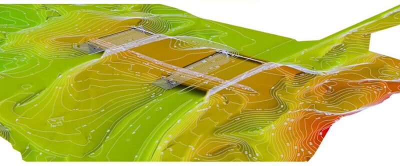
- 3D terrain models (Digital Terrain Models)
- CAD files ready for architectural and engineering use
- GIS layers for geographic and environmental analysis
- Architecture:Designing buildings that blend naturally with the environment
- Infrastructure:Roads, bridges, and utilities require precise land data
- Agriculture:Planning irrigation and land management efficiently
- Environmental Monitoring:Tracking changes in ecosystems
- Disaster Management:Mapping vulnerable zones like flood plains and landslides
- Accurate understanding of the land
- Fewer unexpected challenges during construction
- Smarter and safer design choices
- Compliance with legal requirements
- Environmentally responsible development
Hearing the Land’s Silent Story
Before a building rises or a road winds through the earth, there’s a quiet, essential step: truly knowing the land beneath us. This begins with a topographical survey—a thoughtful exploration that captures every curve, contour, and feature of the terrain.
It’s more than lines on a map; it’s a way to read the landscape’s story, written patiently by nature over countless years.
Let’s journey into topography, where science and art unite, revealing the shape and spirit of the land.
Understanding Topography
Topography refers to the detailed study of the physical features of a landscape—its hills, valleys, slopes, and the placement of natural and man-made elements. It reveals the unique form of the earth’s surface in any given place.
Simply put, topography tells us: How does this land rise and fall? What shapes does it hold?
Defining a Topographical Survey
A topographical survey is a precise and comprehensive examination of a specific piece of land. It measures the exact location and height of all visible features, whether natural elements like trees and rivers or constructed objects like buildings and roads.
Using advanced technology—GPS devices, laser scanners, and total stations—surveyors collect detailed data that forms the foundation for architects, engineers, and planners to work from.
What Does a Topographical Survey Cover?
These surveys map out:
All gathered information is then transformed into clear, detailed maps and 3D models, guiding thoughtful planning and design.
Why Are Topographical Surveys Crucial?
Topographical surveys act as a bridge between nature’s reality and human vision:
The Role of Laser Mapping in Modern Surveys
The advent of Laser Mapping and LiDAR technology has revolutionized how surveys are done. By emitting laser pulses over the land, these tools collect vast amounts of data points that create incredibly precise 3D images—even through dense foliage or over difficult terrain.
Drones fitted with LiDAR scan large areas rapidly and with great accuracy, capturing details invisible to traditional surveying methods.
Advantages include:
How a Topographical Survey is Conducted
The typical process includes:
Deliverables from a Topographical Survey
Clients usually receive:
These outputs serve as essential tools for successful project planning.
Applications of Topographical Surveys
Topographical surveys are indispensable in fields such as:
Topographical Surveys Across India
India’s diverse geography—from towering mountains to fertile plains—makes these surveys vital. They help manage urban growth, infrastructure projects, water resources, and sustainable agriculture, ensuring development respects the country’s unique landscapes.
Why Invest in a Topographical Survey?
Conducting a topographical survey ensures:
Final Thoughts: Listening to the Land
A topographical survey is not just a technical task; it is a respectful conversation with the earth. It honors the land’s history and guides us to build wisely, creating spaces that harmonize with nature.
Before breaking ground, pause and listen—the land has stories to tell. A topographical survey is how we capture those stories and turn them into the foundation of our future.
Read More: What is Lidar Technology?