
3D Scanning for BIM modelling
3D Laser Scanning
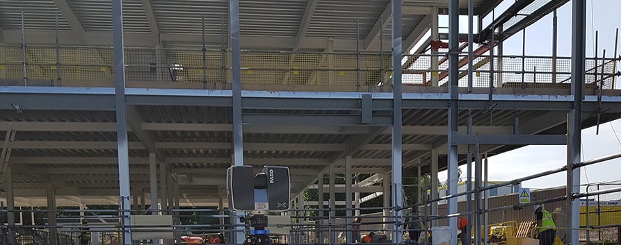
Laser Surveying | Surveying with 3D Scanner
Most offshore facilities and platforms require constant maintenance and upgrades. Accurate information on these channels is essential in order to ensure a safe and productive work environment. Our laser surveying scanning services provide 3D construction documentation for internal tools and systems, such as processing plants, surveying facilities or geotechnical engineering and technical equipment of the building.
Faro Focus can help to conduct survey for any site, including, excavation or archaeological site, tunnel or mine. It helps to observe and review the site and conduct survey on periodic basis easily. The laser scanners also allow sharing digitized reports with the team to collaborate and work remotely.
The 3D laser surveying scanner can reduce the construction cost of roads, bridges, sewerage, etc. by modern digital technology cost effectively; it can reduce reconstruction, improved coordination and supervision of all work. We serves in Vadodara, Rajkot, Ahmedabad, Surat, Mumbai, Delhi.
- Accurate mapping of site
- Precise geometric registration
- For facility management, maintenance, and training
- Ameliorated coordination and surveillance of assignment
- Mitigation of risk and cost to reconstruction
- Terrestrial Laser Scanning
- Mobile Laser Scanning
- Offshore Scanning
- High definition Surveys / Laser Scanning
- Aerial Surveys
- Site Detail & Feature Surveys
- Volumetric Surveys
- Lease Surveys
- As-constructed Surveys
LiDAR Technology allows us to virtually map everything from large scale city model to very small industrial component. It also helps to reduce the construction cost of roads, bridges, sewerage, etc. by using FARO 3D laser surveying scanning technology.
FAQs
It captures precise site data in 3D, including terrain, structures, and utilities, aiding accurate planning and execution.
It ensures exact measurements for foundations, layout, and structures, reducing errors and rework.
Yes, it identifies terrain irregularities, underground utilities, and spatial constraints before work begins.
Absolutely, laser scanning and photogrammetry significantly reduce field time compared to manual surveys.
Yes, accurate data allows precise material calculations, reducing waste and improving budgeting.
Yes, scanned site data can be used in BIM for planning, clash detection, and coordination.
It reduces manual measurements in hazardous areas, minimizing risk to workers.
Yes, repeated scans allow comparison with design models to monitor progress and detect deviations.
Absolutely, they provide accurate mapping for roads, utilities, bridges, and large civil structures.
Yes, existing structures can be scanned for precise planning of upgrades or modifications.