
- Millimeter-Level Precision: Recording millions of data points in fractions of a second guarantees accurate measurements.
- High-Resolution 3D Models: Develops high-granularity topographic maps and BIM for scientific planning.
- Error Reduction: Helps in the lowering of errors during project estimates and design changes.
- Quick Data Collection: LiDAR scanners get the data in a matter of minutes over big areas.
- Less Manual Work Required: The collected data is fed directly into digital models.
- Real-Time Insights: Some advanced LiDAR systems provide real-time processing, enabling them to offer immediate analysis.
- Detailed As-Built Models: Offers a detailed view of structures for renovation and structure expansion.
- Improved Representation: Three-dimensional models enable architects, engineers, and clients to visualize designs before construction begins.
- Space Optimization: Better planning of layouts for structures, utilities, and infrastructure.
- Non-Contact Surveying: This allows data collection from a distance, minimizing the need for personnel in hazardous areas.
- Hazard Identification: Before construction, scans can help identify potential obstacles, ground that isn’t stable, or any other safety hazards.
- Structural Integrity Monitoring: LiDAR helps in identifying any deformation, cracks, or other types of structural weaknesses in existing buildings.
- Identifying any design clashes early: Guarantees proper fit among architectural, electrical, and mechanical components.
- Quality Assurance: With regular scanning of construction sites, teams can easily compare what has been built with what has been designed.
- Reducing Material Waste: Accurate measurements allow for just the right amount of construction materials to be ordered and utilized.
- Topographic Mapping: Enables engineers and surveyors to use detailed elevation models for developing drainage, site, and foundation work.
- Vegetation and Obstruction Detection: Tracks trees, buildings, and other obstructions that could impact construction.
- Flood & Soil Stability Analysis: Assist in determining whether there are potential hazards such as flooding, landslides, or unstable soil conditions.
- Accurate Digital Twins: Build virtual models of the site, accessible to all team members from a remote location.
- Improved Collaboration: Teams use shared 3D models for data-driven decisions.
- Clear Documentation: LiDAR scans provide a digital record of the site condition at various project stages.
- Minimizing Material Waste: Precise planning reduces the waste of materials and construction debris.
- Optimizing Resource Use: Assists in creating real estate adjusted to past climates.
- Minimizing Environmental Impact: Looks to minimize the impact of deforestation, erosion, and habitat disruption in site development.
- Infrastructure Development: Roads, bridges, railways, and tunnels benefit from accurate terrain mapping.
- Building Renovation and Restoration: Assists architects with the historical preservation of buildings through accurate measuring.
- Urban Planning: Aids city planning by mapping out buildings, utilities, and road networks.
Introduction:
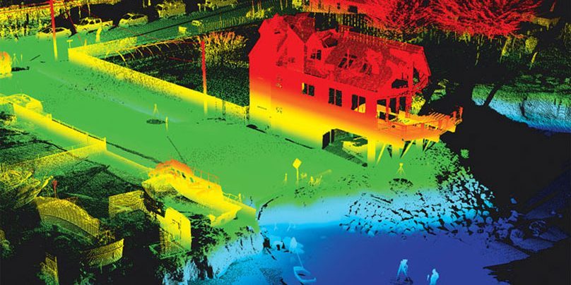
LiDAR (Light Detection and Ranging) scanning has changed the construction industry by providing accurate 3D data and detailed data of sites, structures, and surroundings. By measuring distances and creating digital models with lasers, this technology radically increases project efficiency and lowers risks.
This blog will take a closer look at the top benefits of using LiDAR scanning in construction and determine why it has become critical to modern projects.
1. Unmatched Accuracy and Precision
Another top benefit of LIDAR 3D Scanning in India for construction is the extreme data accuracy that the process captures. Traditional surveying techniques rely on manual precision measurements, which can lead to human error, while LiDAR offers:
Such accuracy level enables engineers and architects to make informed decisions and avoid costly mistakes.
2. Faster Data Collection and Processing
Conventional surveying processes can be tedious, involving several site visits and manual computation of figures. LIDAR 3D scanning in India speeds this process up significantly:
Projects are kept on schedule, and unnecessary delays are avoided as data collection is done more quickly.
3. Improved Planning and Design
LiDAR data can be seamlessly integrated into CAD (Computer-Aided Design) and BIM software, improving the accuracy of architectural and engineering designs. This results in:
4. Improved Safety at Construction Sites
Safety considerations carry significant weight in construction, and LiDAR scanning mitigates these in various ways:
The early identification of risks allows construction teams to develop preventive safety measures to avoid accidents and injuries.
5. Cost Savings from Reduced Rework
LIDAR 3D scanning in India assists in lowering these expenses by:
Construction companies rely heavily on planning and management—and when they can make fewer mistakes and get project resources under control, they can reduce expenses quite considerably.
6. Efficient Land and Site Analysis
Benefits of Using LIDAR scanning is especially helpful for site analysis prior to construction, allowing developers to better understand the condition of the land before construction starts. Benefits include:
Conducting a thorough site analysis helps construction teams avoid unforeseen complications that could push the project timeline back.
7. Streamlined Project Coordination & Communication
Construction is a collaborative working environment that encompasses architects, engineers, contractors, and project managers. LiDAR scanning enhances communication through:
When project stakeholders work in sync, projects run more smoothly and move ahead as planned.
8. Environmental Benefits / Sustainability
The construction type is increasingly being scrutinized for sustainability, and LiDAR scanning is helping you promote greener principles for:
9. Versatility across Different Construction Applications
LiDAR scanning is very versatile and can be used in many construction-related use cases, including:
It is due to this flexibility that LiDAR is a critical aspect of several construction processes.
Conclusion
The construction industry has been revolutionized by LiDAR scanning, providing precise, efficient, and safe solutions for surveying. Construction companies can benefit significantly from LiDAR being a smart move towards enhancing productivity, reducing risks, and providing elite results. As the industry moves forward, LIDAR 3D scanning in India will always be the premier tool for modern construction projects. Also Read About How to Choose the Best Laser Scanning Services in India