
- Applications of LiDAR in Road and Highway Construction
- Feasibility study, route planning
- Recognizing the show elements and change in altitude
- True volume earthwork calculation
- Helpful in giving accurate site metrics for foundation planning
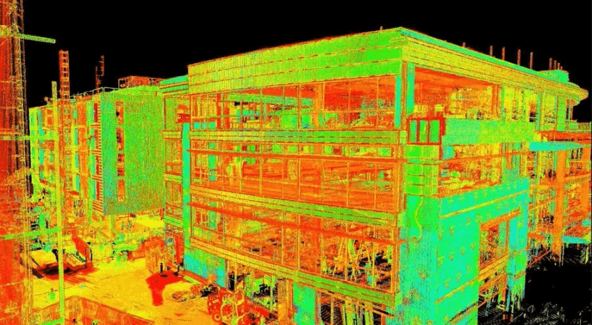
- Helping with façade and structural inspections
- Supporting BIM integration for better project management
- Planting worms for bridge formations
- Maintaining structural integrity during and post-construction
- Making realistic 3D city models for zoning and development
- To understand the traffic and pedestrian flow
- Advancing disaster preparedness and emergency response planning
- Mining firms make use of LiDAR in order to:
- Keep track of stockpile sizes and excavation progress.
- Detect ground instability and improve safety
- Artificial Intelligence and Machine Learning: AI-driven LiDAR analysis is capable of identifying construction defects, predicting schedule delays, and optimizing workflows.
- Cloud-Powered Collaboration: LiDAR Mapping for Construction can be shared instantly through cloud platforms, enhancing the communication between different stakeholders at the project.
- Integration with Robotics: As autonomous construction robots continue to advance, ships with LiDAR can perform inspections on-site and eliminate labor on-site.
Introduction:
LiDAR (Light Detection and Ranging) mapping has transformed the construction industry, providing highly accurate, detailed, and efficient methods for surveying, planning, and tracking construction projects.
LiDAR, which is based on distance measurements using laser pulses, creates an extremely accurate 3D image of an entire construction site, enabling better decision-making, cost reduction, and increased safety.
This blog explores the transformative impact of LiDAR mapping for construction projects, including its benefits, applications, and future potential.
Benefits of LiDAR in Construction
1. Enhanced Site Surveying and Mapping
Land Surveying by Traditional System Traditional land surveying is a manpower-intensive process that takes a lot of time. LiDAR automates this process, gathering data in minutes instead of days. With that in mind, the technology offers information that is very accurate topographical maps, which means fewer human errors and better project planning.
In such cases, LiDAR facilitates accurate mapping of elevation, slopes, and obstacles for a road construction project with centimeter-level precision, enabling precise grading, earthwork calculation, and other essential construction processes.
2. Improved Project Planning and Design
LiDAR surveying in construction creates realistic digital twins of construction sites, which can also be scaled up with LiDAR data with the help of BIM and 3D modeling. These models help engineers and architects by visually presenting the project to them before construction begins, optimizing design, and minimizing expensive changes later on during the construction.
As an example, in the context of urban construction, those 3D models collected with LiDAR allow planners to conceptualize how a new build will impact existing infrastructure,sunlight spaces, and drain systems.
3. Cost and Time Savings
Costs and pre-construction schedules are also greatly reduced by LiDAR. Real-time data collection and processing is allowing construction teams to catch potential issues sooner, helping to eliminate some of the rework and delays. Automated LiDAR mapping also cuts down the requirement of labor and costly surveying machinery.
For a real-world example, consider a highway expansion project where LiDAR is used, providing engineers with detailed terrain data that helps in saving excavation and material costs by planning efficient routes.
4. Increased Safety and Risk Mitigation
Construction sites are dangerous, and surveying on tough terrain can be dangerous. LiDAR enables data collection from a distance, so surveyors do not have to enter hazardous areas. It also aids in the identification of unstable ground, landslide-prone areas, or creeks, which can pose a danger to workers.
For instance, LiDAR is employed in mining construction to scan open-pit mines, identifying structural weaknesses that might cause collapses.
5. Enhanced Monitoring of Construction and Quality Control
LiDAR allows for real-time progress tracking by comparing completed work with digital plans. It also makes sure that structures are constructed as per the design specifications, which reduces errors and improves quality control.
For example, in high-rise construction, LiDAR scans identify misalignment, enabling corrections to be made in real time before they become expensive complications.
6. Sustainable and Environmentally Friendly Construction
LiDAR Mapping of vegetation, waterways, and natural habitats minimizes environmental impact. Construction projects can be designed so that they don’t destroy ecosystems or limit the amount of deforestation based on environmental regulations.
For example, in renewable energy projects such as wind farms, LiDAR analyzes wind flow patterns and terrain to determine optimal turbine placement, maximizing efficiency while minimizing environmental disruption.
Applications of LiDAR in Construction
LiDAR can improve building construction in the following ways:
LiDAR is needed in infrastructure projects for:
LiDAR 3D scanner plays a role in smart city design by:
Future of LiDAR in Construction
With advancements in LiDAR technology,though, that number is growing in construction. Technologies like AI-augmented LiDAR analysis, cloud processing in real time, and connection to self-driving construction equipment are transforming the space.
Emerging trends include:
Conclusion
LiDAR 3D scanners are changing construction projects for the better, improving precision, efficiency, and safety from site surveying and design through monitoring to environmental impact analysis. LiDAR provides critical data that enables smarter decision-making.
With advancements in technology, construction management is sure to become more effective and reliable, resulting in smarter, faster, and more sustainable projects. Large-scale efficient LiDAR systems are now trending due to their usability in each industry and their advantages over the traditional process.
Read More: Why Large Scanner Services Are Essential for Architectural Projects