
- A radar transmitter emits electromagnetic waves in the radio spectrum.
- These waves travel until they hit an object.
- They reflect back to the receiver.
- The time delay and shift in frequency are analyzed to determine:
- Distance
- Velocity (via Doppler Effect)
- Position
- Direction of movement
- Pulse Radar: Sends out bursts of waves; good for long-range detection.
- Continuous Wave Radar: Constantly sends waves; better for tracking movement.
- Synthetic Aperture Radar (SAR): Used for creating detailed 2D and 3D maps from aircraft and satellites.
- Emits rapid laser pulses (often hundreds of thousands per second).
- Each pulse hits a surface and reflects back to a sensor.
- The time of flight is measured to determine exact distance.
- A lidar 3d scanner compiles millions of these points into a detailed 3D point cloud of the scanned area.
- Terrestrial LiDAR:
- Aerial LiDAR:
- Mobile LiDAR:
- Self-driving vehicles (recognizing lanes, pedestrians, obstacles)
- Surveying buildings and landscapes
- Archeological exploration (revealing hidden structures under vegetation)
- Urban planning (capturing real-world data for smart cities)
- Autonomous Vehicles: Detect road edges, lanes, people, and obstacles in real-time.
- Urban Mapping: For smart city development and infrastructure planning.
- Forestry: Estimating tree heights, canopy structures, biomass.
- Mining & Construction: Site modeling, volume calculations.
- Archaeology: Discover hidden ancient ruins under dense forests.
- Aviation: Aircraft tracking, collision avoidance.
- Meteorology: Weather prediction and storm tracking.
- Defense & Military: Surveillance, target tracking, missile systems.
- Marine Navigation: Detecting other ships or obstacles in fog or dark.
- Automotive: Adaptive cruise control, lane change warnings, rear cross-traffic alerts.
- Superior for detecting moving objects at long ranges.
- Less detailed but more resilient to external conditions.
- LiDAR struggles in poor weather due to light scatter from fog, rain, or dust.
- Radar is unaffected by most weather since radio waves pass through atmospheric interference easily.
- Radar is generally cheaper and already mass-produced for cars and defense systems.
- LiDAR is more expensive due to complex hardware, though costs are dropping fast due to innovation in solid-state LiDAR.
- LiDAR provides high-resolution environmental modeling.
- Radar tracks the speed and movement of objects—even in poor visibility.
- Cameras add color and texture context.
- Solid-State LiDAR: No moving parts, smaller, cheaper, more durable.
- Flash LiDAR: Captures entire scenes in a single shot like a camera flash.
- Phased Array Radar: Offers faster scanning, higher tracking precision.
- AI-Enhanced Radar: Identifies object types (pedestrians vs. cars) with better accuracy.
Introduction
In our increasingly automated world, the ability to detect, recognize, and map surroundings in real-time is critical. Two of the most powerful technologies that help machines “see” their environment are LiDAR and Radar. Although they may seem similar, they function differently and are suited for different tasks.
Understanding the difference between LiDAR and Radar can help businesses, engineers, and tech enthusiasts choose the right technology for their needs.
What is Radar?
Radar: A Long-Time Player in Detection Tech
Radar, or Radio Detection and Ranging, has been around since World War II. It sends out radio waves and listens for echoes when those waves bounce off objects.
How Does Radar Work?
Types of Radar
What is LiDAR?
LiDAR: Precision with Light
LiDAR, or Light Detection and Ranging, is a newer, light-based sensing method. It uses lasers (often in the infrared spectrum) to scan environments with incredible accuracy.
How Does LiDAR Work?
Types of LiDAR
What is a LiDAR 3D Scanner?
A LiDAR 3D scanner doesn’t just measure distance—it builds realistic, three-dimensional maps of terrain, objects, buildings, and more. It’s like giving robots and machines a highly detailed digital eye.
How LiDAR 3D Scanners Are Used:
| Category | LiDAR | Radar |
|---|---|---|
| Wave Type | Laser Light | Radio Waves |
| Wavelength | Shorter (light) | Longer (radio) |
| Resolution | High (millimeter to cm) | Low to Moderate |
| Weather Performance | Affected by fog, rain, dust | Excellent in all conditions |
| Data Output | 3D Point Clouds | 2D Range and Speed Data |
| Detection Range | Short to Mid (up to 200m) | Long Range (several km) |
| Cost | Expensive | More Affordable |
| Ideal Use Case | Mapping, autonomous driving | Speed detection, tracking |
LiDAR and Radar Applications
LiDAR Applications
Radar Applications
Which is More Accurate?
LiDAR: Sub-Centimeter Precision
Performance in Weather Conditions
Cost and Commercial Use
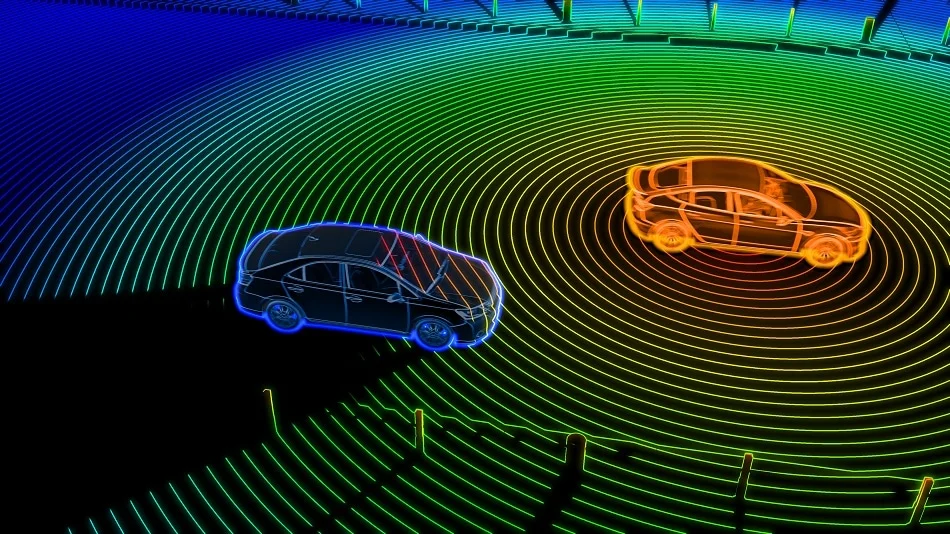
Integration in Autonomous Vehicles
Autonomous vehicles often use a sensor fusion approach:
This combination gives self-driving cars multi-layered vision—like having eyes, ears, and intuition working together.
Technological Evolution
LiDAR Innovations:
Radar Innovations:
Which One Should You Choose?
| Purpose | Best Tech |
|---|---|
| Precision Mapping | LiDAR |
| Object Detection in Bad Weather | Radar |
| Long-Range Surveillance | Radar |
| 3D Scene Reconstruction | LiDAR |
| Budget-Conscious Applications | Radar |
| High-Speed Object Tracking | Radar |
| Detailed Urban Navigation | LiDAR |
Final Comparison Table: LiDAR vs. Radar
| Feature | LiDAR | Radar |
|---|---|---|
| Technology | Laser-based sensing | Radio wave-based sensing |
| Resolution | Very high (millimeter-level) | Lower (limited detail) |
| Range | Medium (up to 200 meters) | Long range (several kilometers) |
| Weather Resilience | Poor in rain/fog/dust | Excellent in all conditions |
| Output | 3D point cloud | Speed, range, movement info |
| Cost | High | Moderate to Low |
| Main Use Cases | Mapping, 3D scanning, AVs | Military, weather, automotive |
| Working Principle | Time-of-flight of laser pulses | Echo timing of radio waves |
| Suitability | Precision-focused tasks | Broad, general detection |
| Integration Potential | Best when combined with other sensors | Excellent with AI for object tracking |
Read More: What Is BIM Modelling? Benefits, Uses, and Future Trends