
- It can be used to create 3D representations of spaces in high spatial resolution and thus operate to allow users to view and read spaces in new ways that were previously unimaginable.
- It helps to develop depth perception, discover the concealed characteristics, and provide the objectivity of data analysis that enables better decision-making in different spheres.
- It may also allow for simulations of foot traffic, vehicle traffic, or temporary construction impacts.
- This type of spatial data is critical in smart city comprehensive approaches, infrastructure management of public-owned utilities, and public safety.
- Cost:High-end LiDAR scanners and processing software can cost a lot of money.
- Data Management:All of that data collected has some serious capabilities for some serious data management and processing.
- Skillset:LiDAR data has its level of expertise and training to interpret as well.
- Privacy:Scanning in an urban environment usually leads to additional privacy concerns based on how well the LiDAR data is scanned and ethically handled.
As we live in a data-centric society where precision takes precedence, understanding space has never been so important. Whether it is urban planning, environmental monitoring, autonomous navigation, or even archaeology, one technology has emerged as revolutionary: laser mapping.
But how Laser Mapping enhance spatial Understanding beyond providing beautiful 3D images? It can be termed as a game-changer in terms of how we think, perceive, understand, visualize, analyse, and interact with our world.
What is Laser Mapping?
Remote sensing, Laser mapping, or LiDAR (Light Detection and Ranging) is a remote sensing technique that measures the distance to the surface using a laser beam. The distance is then mapped into high-detail 3D models of objects, landscapes, and environments.
The technology works by firing off laser pulses in rapid succession, then calculating how long it takes the pulse to return to the detector. An even more accurate laser mapping system uses your accurate GPS tethered with an inertial measurement system (IMS), and from those elements creates an extremely accurate point cloud modelling the physical space around you.
At Fibrox3D, we use geospatial-based Laser Mapping tools to most accurately depict and present our clients' real-world spaces in true millimeter precision.
From 2D to 3D: A New Dimension of Insight
Conventional mapping methods were based considerably on 2D depictions—flat maps, sketching, or satellite imagery. But these images tend to be lacking in portraying elevation, volume, or structural complexity. This is where the laser mapping revolutionizes the game.
Fibrox3D offers scalable 3D mapping services to map everything that befits it; from a small premise to a large area, all to make your space a digital asset.
Applications: Real-World Impact of Laser Mapping
To understand how laser mapping can improve awareness of space, let's discuss how it can be used in real applications across sectors:
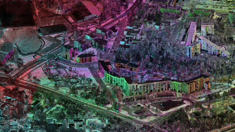
1. Urban Planning and Smart Cities
Urban planners are able to laser map cityscapes and municipal infrastructure. The 3D models of real buildings, real roads, and public utilities may allow architects to design spaces that are more functional and less congested.
2. Environmental and Forest Monitoring
Foresters and ecologists often use laser mapping, or LiDAR mapping in their case, to assess and identify changes in vegetation loss, tree height, biomass value, and topography.
Whether physically flying over the forest with a drone or by satellites, one big advantage is that, unlike conventional satellite imagery, LiDAR will recognize the canopy and is still able to capture some of the ground information despite some rooted vegetation.
3. Disaster management
In those areas where natural disasters such as earthquakes, floods or landslides have very high probabilities, there is a need to do laser mapping. One can also use it to monitor the development of zones within a very short time, tracking the presence of architectural structures that can cause danger, and to devise controlled evacuation plans.
4. Autonomous Vehicles, UAVs, and Drones
Laser mapping is the main navigation system used in self-driving cars and autonomous UAVs (unmanned aerial vehicles). The ability to create spatial maps in real-time provides the vehicle or UAV the ability to identify obstacles, measure distances, and traverse areas in much more complex ways quickly and easily.
5. Construction and Infrastructure Management
Construction and infrastructure experts use laser mapping in a bundle of operational applications like structural analysis, site surveys, progress monitoring, etc.
The engagement of 3D point cloud surveying and imaging allows engineers and professionals to compare existing site condition standards against the project blueprints to identify changes or variations to the plans; thus reducing rework associated.
6. Archaeology and Heritage Preservation
Archaeologists have utilized laser mapping techniques to uncover and store ancient sites. LiDAR surveying can measure and capture obscured structures underneath forest canopies or eroded ground, paving the way to revealing ruins that were previously unknown.
Along with high-resolution scanning for digitally preserving cultural heritage landmarks, we ensure that even if we lose the legacy of the physical structure, the heritage remains preserved digitally.
Our expert team at Fibrox3D works with archaeologists and other institutions to record and preserve historic sites using non-invasive laser mapping technology.
Key Benefits of Laser Mapping in Enhancing Spatial Understanding
After understanding the applications, let's talk about some specific benefits that describe how laser mapping provides knowledge of spatial relations:
A. Precision and Accuracy
The conventional measurement has a high level of errors caused especially on rough terrains but laser mapping is able to give a level of accuracy to about millimeters in areas that may be inaccessible or where there is no good visibility. It is this accuracy that allows improved spatial decision-making!
B. High resolution visualization
Whether you are planning to produce scans on a city skyline or a cave wall, high-detail 3D modelling can always be retrieved by laser mapping and with its millions of data points. These graphics do not only look interesting; they provide structure, texture and elevation unable to be presented with 2D maps.
C. Quick Data Gathering
LiDAR sensors effectively amass large amounts of spatial data in minutes. The rapid collection of data is extremely valuable during required immediacy timeframe assessments, such as in disaster situations or construction progress updates.
D. Scalable and Flexible
Laser mapping can employ various different ranges from persons using handheld scanners to persons using drones and other aircraft. Laser mapping is flexible and effective in all environments, as it can map small areas or large areas equally well.
E. Real-Time Information
Modern systems can quickly process laser mapping data in real-time and are assigned the urgency for these types of systems. The ability to receive instantaneous spatial feedback enables faster and more adaptable services in changing environments.
Future of Laser Mapping: AI and Integration
The future of laser mapping services is to integrate with more advanced artificial intelligence (AI) neural networks, big data, and machine learning.
By leveraging AI-driven algorithms, point clouds collected through laser mapping can be classified automatically and analyzed in real time to distinguish and analyze trees, roads, buildings, water, etc.
In addition, in terms of Spatial Modeling, Terrain Analysis, and Predictive Simulations, GIS helps combine Laser Mapping with advanced artificial intelligence (AI) and big data analytics.
The incorporation of augmented reality (AR) and virtual reality (VR) will expand the usefulness of laser mapping by helping to generate and provide immersive spatial data experiences with site-specific planners, undergraduate and graduate students, and researchers in other disciplines.
Challenges and Considerations
While there are huge benefits to laser mapping, there are areas of concern:
That is where Fibrox3D comes in. We take away that technical complexity and offer end-to-end laser mapping solutions: scanning, processing, and delivering results.
Conclusion
How laser mapping enhances spatial understanding? In countless ways. Speed, depth, and even accuracy as a method of visualization can likely far exceed what most other methods can accomplish.
Fibrox3D allows you to drastically improve your outcomes in the long term by allowing up to offer laser mapping solutions for industries that provide high-level and high-resolution laser mapping services. Whether it's planning a city, preserving a monument, or even tracking the shifts of terrain over time,, and high resolution.We prat ovide you with the spatial intelligence and data to make better decisions and make decisions quicker.
Join Fibrox3D—and explore the potential, visualizing the future, completely altering the way to see the world. With advanced laser mapping, your perspective, planning, and future might be smarter.
Read More: Preserving Heritage with 3D Laser Scanning & Heritage Scanner