
- Drones kindly occupy airspace over areas of interest for the collection of geo-information that professionals will later put together into maps or 3D printing models for other purposes.
- Considerably faster than conventional ground-surveying methods, drone surveys keep people out of harm's way while providing higher accuracy.
- Many new and seasoned companies are performing drone surveys in agriculture, mining, real estate, and public works.
- Some states, specifically Maharashtra, Karnataka, and Uttar Pradesh, have adopted drone technology in the practice of land records and city planning.
- This is a significant step forward in showcasing drone technology in any capacity, and it most definitely demonstrates the potential space for drone surveying in India's economy.
- Regulatory Restrictions: DGCA (Directorate General of Civil Aviation) rules control drone operations. Getting the go-ahead to fly in off-limits areas can take a long time.
- Not Enough Skilled Operators: There aren't many trained drone pilots and data experts who can run the gear and make sense of the data well.
- Infrastructure Gaps: To process the huge amount of data drones create, you need top-notch software and hardware. These might not be easy to find in country areas or less developed regions.
- Privacy Worries: Drones take detailed pictures from above, which raises concerns about spying, misuse of data, and stepping on people's right to privacy.
- Drone Rules 2021: These new regulations make the drone certification process easier, cut down on bureaucracy, and create chances for business use.
- PLI Scheme for Drones: The Production-Linked Incentive scheme influences the manufacturing of drones and their parts in India. This cuts down the need to import.
- Drone Shakti Programme: Budget 2022 introduced this plan to boost drone-as-a-service (DaaS) startups. It focuses on farming and supply chain areas.
- AI and machine learning: influence data analysis so that reports are done more quickly and with greater insight. Machine learning has been designed to work faster with the help of AI. Cloud allows any stakeholders to work in real-time seamlessly.
- Growth in Public and Private Partnerships: This has enhanced competitive advantage through co-operation between government agencies and private companies, thereby increasing drone usage across a wide variety of domains.
The technological revolution that India is showing witness to, especially the great advancement in drone technology, in itself is a great sight in the skies. The work pattern of the industries is rapidly changing from innovative aerial photography to delivery services.
Among others, drone surveying in India is fast becoming an innovative and pathbreaking tool in the construction, agriculture, infrastructure, and land management sectors. To sum up, The Future of drone surveying in india is bright with possibilities, while its focus on efficient planning, resource management, and decision-making will be critical.
What is Drone Surveying?
Drone survey is the design and implementation of a survey using unmanned aerial vehicles (UAVs) with sophisticated cameras and/or sensors to collect this information.
In an enormous and diverse country like India, where land conditions and all-weather accessibility differ vastly, the Future of Drone Surveying in India technology offers invaluable remedies to overcome such physical barriers.
The Rise of Drone Surveying in India
Over the last few years, drone technology has increased in its application within India. Initiatives like the Digital India Land Records Modernization Programme (DILRMP) and Swamitva Scheme from the government have assisted in boosting the application of drones in land mapping with rural development.
Benefits of Drone Surveying for India
Drone surveying has benefits that are useful in India:
1. Speed and Efficiency: Drones can complete a very extensive area in a much shorter time than a surveying team. Some tasks may take weeks to accomplish manually, but those very same tasks can completed in days or even hours through the use of drones.
2. High Accuracy: With GPS, LiDAR, and photogrammetry capabilities, drones give data that is very accurate and detail-oriented; the precision of such information is especially paramount in construction where even the smallest errors can bring about very big money problems.
3. Cost-Effective: Drones are not capital-intensive because, although high capital is involved in the acquisition of drones, they save costs in terms of man-hours that would otherwise have been spent on trips and repeated work. An economy like that of India greatly cherishes saving money.
4. Places Hard to Reach: The territory of India has forests and mountains, deserts, and even faraway villages. Manual surveying becomes extremely difficult and risky; drones, however, can cover the area quickly without compromising access and coverage.
5. Enhanced Safety: The prospect of injury or accident is lowered since drones do not require surveyors to go into potentially unsafe statistics zones.
Key Applications in India
1. Land Mapping and Records: This keeps disputes regarding lands away and provides for a sound record of the properties for the purposive intents of finance as well as law.
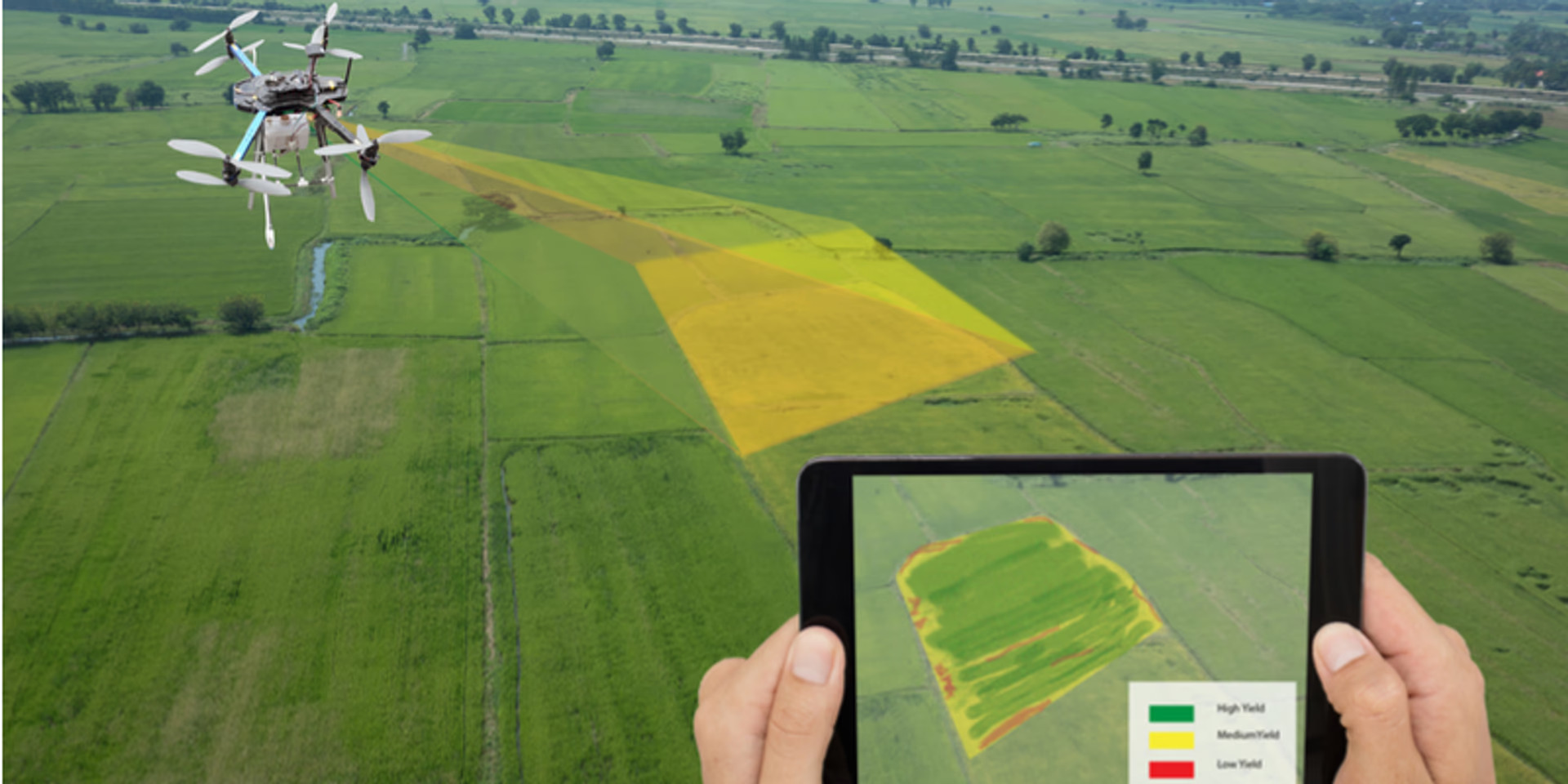
2. Agriculture: In India, agriculturalists have started using drones to find crop health, soil analysis and precision agriculture. Drone surveys teach farmers to manage their water and fertilizer inputs much better leading to more productive farms.
3. Construction and Infrastructure: Drone surveying in India is helpful in the site inspections, progress checking and design validation for roads, bridges and industrial areas. It is also a very important component of smart city project planning.
4. Disaster Management: During the occurrence of any disaster, the entire direct area might have a large deployment of drones that could help find and assess damage to victims and direct rescue teams without putting humans in danger.
5. Mining and Quarrying: Drone surveying in India has the advantage of being able to do volume calculations and monitoring of the operations in the mines, thus ensuring that the mines operate under the provisions of environmental and mining regulations.
Challenges Facing Drone Surveying in India
Government Initiatives Supporting Drone Surveying
To give a boost to drone surveying in India, the government has rolled out several policies and schemes:
These steps show how committed the government is to making drones a part of India's economic and tech growth plans, turning the future of drone surveying in India into a real thing, not just an idea.
Future Outlook: What's Next?
As drones get cheaper and their programs get better, India will see a big jump in how people use drones for surveying. We can expect to see these changes:
All these factors make customized solutions for every industry. For example, these are drones custom-built for specific needs, owing to the oil & gas, telecommunications, and renewable energy industries.
Conclusion
The future of drone surveying in India looks bright. As drones get better, the government backs their use, and industries want them more, India could lead the world in this field. The land is bumpy; however, good things do prevail in this vast, diverse country called India.
Drones are changing the face of agriculture, construction, and governance in a big way, bringing with them more intelligence, time, and equity for all. Drone Surveying in India isn't just coming soon, it's already taking off and flying high. Also Read About Benefits of Reverse Engineering Services for Modern Industries