
- LiDAR Applications in Industry: Autonomous Vehicles Inaccurate data would cause vehicles to misread their surroundings, resulting in accidents.
- Surveying & Mapping: Conventional surveying techniques like GPS and photogrammetry may not offer the same level of accuracy in dense vegetation or irregular terrain.
- Disaster Response: After disasters like earthquakes or floods, LiDAR can rapidly evaluate structural damage, aiding emergency responders in decision-making.
- Forestry and Agriculture: Farmers and environmentalists analyze terrain, measure forest density, and optimize agricultural planning with LiDAR—all in no time.
- Archaeology: Without digging, historical sites and buried structures can be mapped quickly and efficiently, aiding researchers in preserving cultural heritage.
- Autonomous Vehicles: Unlike cameras, which struggle to work in low-light or high-light conditions, LiDAR can ensure that self-driving cars can “see” their environment even at night.
- Military & Security: 3D laser scanning technology is used in surveillance and reconnaissance operations to detect threats in complete darkness or foggy conditions.
- Maritime & Aviation: LiDAR helps map the ocean floor even in turbid conditions where traditional cameras have no luck.
- Forestry & Ecosystem Management: LiDAR allows researchers to estimate the height, biomass, and density of trees and vegetation. It has widespread application in conservation to detect deforestation and habitat loss.
- LiDAR Technology: The technology that uses pulses of laser light to look through vegetation to find ancient ruins. It enables archaeologists to visualize historical sites without destroying the ecosystem.
- Topographical Mapping: For land cover types with thick vegetation, we can create detailed elevation models (DEM) too, which is critical to assess the land use and flood risk.
- AI: AI-enabled LiDAR systems can automatically detect and identify objects, enhancing use cases such as smart city planning and collision avoidance.
- Augmented Reality (AR): AR applications like Apple's ARKit leverage LiDAR to enhance depth sensing and spatial mapping in mobile devices.
- Geospatial Data Systems (GIS): Governments and industries utilize LiDAR-integrated GIS systems for enhanced decision-making in infrastructure development, environmental observation, and urbanization.
Introduction:
LiDAR (Light Detection and Ranging) is a remote sensing technique that emits laser pulses to measure distances and create detailed maps of the surroundings. It has become popular in different industries, such as self-driving automobiles, environmental monitoring, and urban planning.
LiDAR is one of those technologies that has updated conventional surveying methods to get you speed, accuracy, and versatility all in one tool. This blog covers the five biggest advantages of LiDAR laser technology.
1. High Precision and Accuracy
LiDAR is known for its relative precision and accuracy in measuring distances and mapping environments, which is one of its main features.
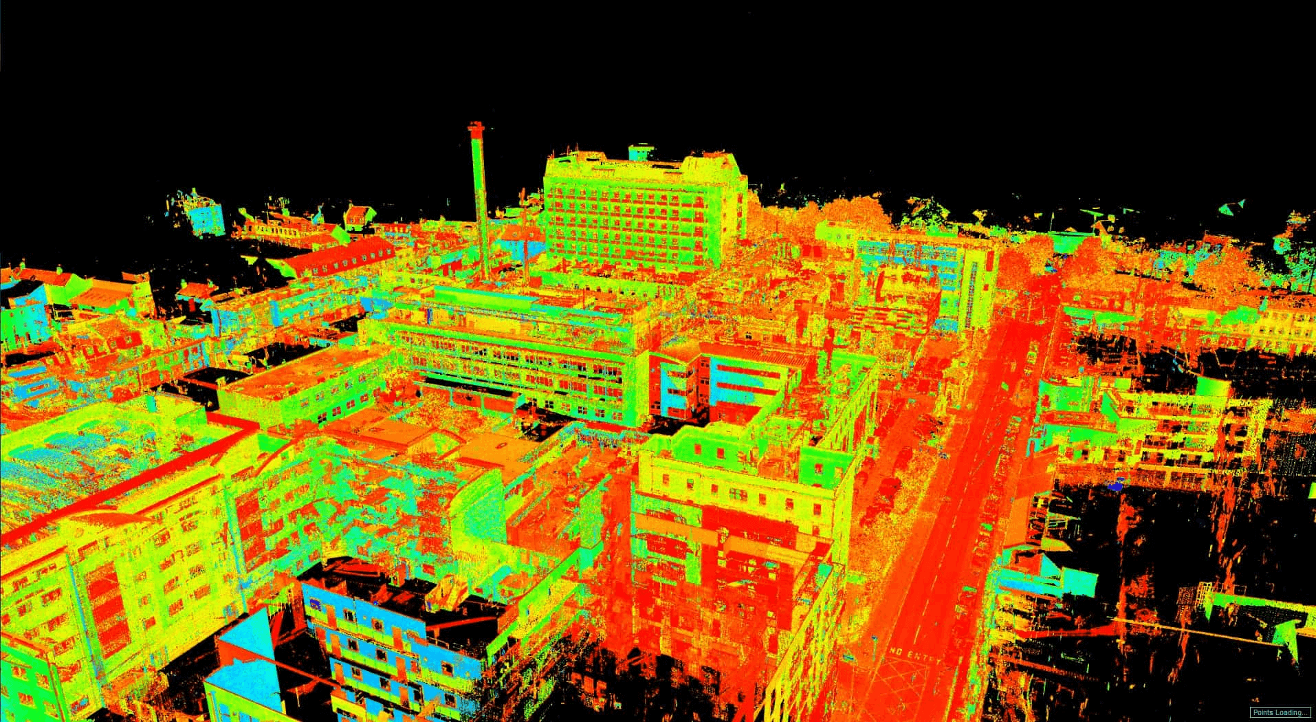
LiDAR sensors fire laser pulses that receive backscattered light after reaching their target and return to the sensor for distance calculation according to the travel time of the light to the target and back.
The time-of-flight (ToF) principle means that the LiDAR can create high-resolution 3D models accurate to the centimeter or even millimeter level.
Why is accuracy important?
Urban Planning & Infrastructure: Engineers constructing buildings, bridges, and roadways rely heavily on accurately produced models of the terrain, which, when produced using GIS data, can be definitive and with minimal error.
LiDAR also provides much more detail than other remote sensing modalities, such as radar or cameras, and is therefore preferred in cases where more precision is required.
2. Fast Data Collection and Processing
If we talk about the other main benefit of LiDAR, it is collecting and processing vast data in a short time span. Manual surveying, on the other hand, can take days, or even weeks—LiDAR can scan and map an area in a few hours.
Speed Matters in Various Applications
Contemporary 3D laser scanning technology comes with AI-based software, meaning that data analysis is pretty much automated, which greatly reduces processing time, further increasing its efficiency.
3. Works in Various Lighting and Weather Conditions
LiDAR does not depend on ambient light to operate, unlike cameras or other optical sensors. So in any conditions, whether day or night, it is useful and thus reliable in any environment.
How This Benefit is used in Real-World Scenarios
As an added advantage, certain LiDAR systems utilize wavelengths capable of penetrating fog, rain, and dust, ensuring superior performance in harsh weather conditions.
4. Ability to Penetrate Dense Vegetation
LiDAR has the unique function of penetrating through tree canopies and dense vegetation, making it useful for a variety of applications, including forestry management, archaeology, and environmental research.
Key Applications
In these situations, traditional optical sensors face challenges in collecting data since the area is usually densely signed, but LiDAR does not share the same limitations, thus being a better alternative to map forest areas.
5. Versatile Integration with Other Technologies
LiDAR is a very flexible technology that can be combined with many other technologies in order to get more features. Usually integrated with GPS, drones, AI, and machine learning for greater efficiency and automation.
Examples of LiDAR Integration
The versatility of 3D laser scanning technology enables it to be used in various industries, helping various industries consistently innovate and advance the technology.
Conclusion
These advantages of LiDAR laser, including high precision, the ability to collect data quickly, the ability to operate in all lighting conditions (e.g., day or night), penetration through dense vegetation, and the ability to easily integrate with other advanced technologies, make LiDAR technology a game-changer in many sectors. From self-driving cars to archaeology, LiDAR remains a ground-breaking tool in modern use cases, but that’s just for starters. Also Read About Top Benefits of Using LIDAR Scanning for Construction.